Tyrebagger
Recumbent Stone Circle (Neolithic) - (Bronze Age)
Site Name Tyrebagger
Classification Recumbent Stone Circle (Neolithic) - (Bronze Age)
Alternative Name(s) Standingstones; Tyrebagger Hill; The Standing Stones Of Dyce; Tyre-bagger
Canmore ID 19513
Site Number NJ81SE 11
NGR NJ 85950 13217
Datum OSGB36 - NGR
Permalink http://canmore.org.uk/site/19513
- Council Aberdeen, City Of
- Parish Dyce
- Former Region Grampian
- Former District City Of Aberdeen
- Former County Aberdeenshire
NJ81SE 11 85950 13217
(NJ 8595 1321) Stone Circle (NR)
OS 6" map (1928)
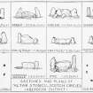
A circle of stones, approximately sixty feet in diameter, on Tyrebagger Hill, is in a very conspicuous position. The stones vary from three feet high ( the stone directly opposite the recumbent stone) to nine feet five inches and eleven feet high (the two pillar-stones flanking the recumbent stone). The recumbent stone itself is eleven feet long and canted upon a bedding of small stones.
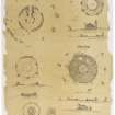
In 1822 there were ten upright stones and one recumbent stone: in 1899 there was an additional upright stone which, with its neighbour, was described as a thin stone, almost a slab. Comparison of the two plans suggests that one of the original stones had been split into these two, possibly when the circle was used as a cattle-fold.
Maclagan is the only authority found to record an inner concentric circle, twelve feet from the main circle, formed of flat stones set edge to edge, and a second concentric circle thirty feet outside the main circle. She believes that the main circle of stones, with the inner circle, formed the limits of a twelve-feet thick wall. The innermost circle is shown, in fragmentary condition, by Coles.
J Logan 1829; C Maclagan 1875; F R Coles 1900
This circle is as described above: Coles' plan is accurate, except for the small group of stones near the recumbent stone. The two 'thin stones' have fallen. The inner concentric circle exists as a retaining bank 0.3m high and 3.0m in from the stone circle. It is only evident on the north segment where, also, several stones stones protrude through the bank. Of the outer circle, only a low spread grass bank, 0.2m high and 9.0m distant from the stone circle, exists, on the SW side.
Visited by OS (EGC) 27 October 1961.
This monument is situated in a clump of beech trees on the edge of a pasture field at an altitude of 130m OD. It commands a wide view to the S, in which direction the ground falls away sharply.
NMRS, MS/712/79.
Publication Account (1986)
Superbly sited on a hill shoulder at c 158m OD, this recumbent stone circle is 18.3m in diameter. The circle stones, from 1m to 2.9m tall, stand in a low stony bank surrounding a fragmentary ring cairn 11.6m across. The characteristic differentiation between the recumbent and the circle stones can be seen here, the fmmer being of dark grey granite (weighing 24 tons) and the latter a red, gritty granite from near at hand.
Information from ‘Exploring Scotland’s Heritage: Grampian’, (1986).
Publication Account (1996)
Superbly sited on a hill shoulder at c 158 m OD, this recumbent stone circle is 18.3m in diameter. The circle stones, from 1m to 2.9m tall, stand in a low stony bank surrounding a fragmentary ring cairn 11.6m across. The characteristic differentiation between the recumbent and the circle stones can be seen here, the former being of dark grey granite (weighing 24 tons) and the latter a red, gritty granite from near at hand.
Information from ‘Exploring Scotland’s Heritage: Aberdeen and North-East Scotland’, (1996).
Field Visit (12 August 1998 - 14 August 1998)
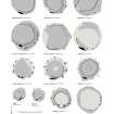
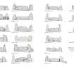
This well-known recumbent stone circle is one of the few that has retained its full complement of stones, standing in the NW corner of a plantation enclosure above Standingstones farm. Set on the leading edge of a terrace on the NE spur of Tyrebagger Hill, it measures 18.5m in diameter and comprises the recumbent setting (1–3) on the S and eight orthostats (4–11); one of the latter (6) was fallen on the day of the survey but had been re-erected by the autumn of 1999. The recumbent slab (2) measures 3.35m in length by 2.4m in height and has an even summit, but it has fallen backwards and rests at an angle on a boulder near its W end. In this tilted position it has proved a convenient hood for a fireplace and the blackening of its inner face is testimony to over a century of picnic fires, eventually splitting the stone and requiring repairs in 1998. The initials JL are carved close to the centre of its outer face. Both flankers remain standing, the western (1) being a slender pillar 3.25m high and the eastern (3) a broader and more pointed slab 2.8m high, but whereas flankers elsewhere so often appear to curve over the ends of the recumbent, here the reverse is true. They are aligned with the front of the recumbent to form a flat façade, and a possible blocking stone can be seen filling the gap between the W flanker and the recumbent. The flankers are the tallest stones in the ring and the tops of the rest of the orthostats are graded to reduce in height from the S down to a stone 1.3m high on the NNE (7). This grading is not matched in the intervals between the stones, and the relatively even spacing around the W and N breaks down on the E, where orthostats 5 and 6 appear to have been inserted asymmetrically and 5 stands a little way inside the circumference of the ring (see below). All the orthostats are now set out along the outer margin of a stony ring-bank 3m thick and 0.5m high, though this probably forms a misleading impression of the original character of the interior of the circle. According to James Logan, writing in the early 19th century, the circle had been used as a cattle pound (1829b, 411), to which end the interior was dug out; a gap in the ring-bank between the W flanker (1) and the neighbouring orthostat 11 probably marks the entrance into the pound. But for Logan’s description, the nine earthfast stones protruding from the inner edge of the ring-bank on the NW quarter might be interpreted as inner kerbstones defining a broad central court, but more probably they are the outer kerbstones of a robbed central cairn about 12m in diameter, which was linked to the back of the recumbent setting by the kerbstones that can be seen embedded in the ring-bank immediately behind both flankers. No other trace of this cairn can now be seen, apart from four displaced kerbstones lying within the interior.
Visited by RCAHMS (ATW and KHJM) 12-14 August 1998


