
Cleaved Head


Promontory Fort (Period Unassigned)
Site Name Cleaved Head
Classification Promontory Fort (Period Unassigned)
Alternative Name(s) Clibet Head
Canmore ID 19298
Site Number NJ76SW 4
NGR NJ 7213 6472
Datum OSGB36 - NGR
Permalink http://canmore.org.uk/site/19298


- Council Aberdeenshire
- Parish Gamrie
- Former Region Grampian
- Former District Banff And Buchan
- Former County Banffshire
NJ76SW 4 7213 6472.
(NJ 721 647) Camp (Remains of) (NR)
OS 25" map, Banffshire, 1st ed., (1869)
At the neck of the headland, Clibet Head (Cleaved Head) are several trenches originally used for burning kelp, as proved on examination.
W Forbes 1897.
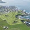
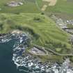
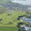
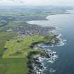
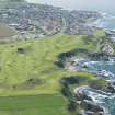
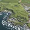
NJ 7213 6472. Two ditches and traces of a third are evident at the neck of the promontory which ends at Cleaved Head. The construction of a golf course has altered the landscape around the ditches, but the easternmost ditch is still the best-preserved, having a scarp 1.5m high and a counterscarp 0.5m high. No evidence of fortification was seen on the flattish top of the promontory but it is possible that these ditches are all that remain of a promontory fort.
Resurveyed at 1/2500.
Visited by OS (EGC) 23 September 1963.
No change.
Visited by OS (RL) 25 January 1968.
(Location cited as NJ 7213 6472: nominated as Site of Regional Significance). Air photography (AAS/77/11/SR/19 and AAS/77/11/RD/30, flown 17 August 1977) has recorded this incomplete promontory fort.
NMRS, MS/712/35.
Scheduled as 'Cleaved Head... promontory fort of prehistoric date, visible as upstanding earthworks.'
Information from Historic Scotland, scheduling document dated 8 November 2005.
Note (22 April 2015 - 18 May 2016)
Access to the precipitous promontory known as Cleaved Head, which lies to the E of Macduff and forms the NW shore of the Bay of Cullen, is barred by three ramparts and ditches forming a belt of defences at least 25m deep across the neck on the WSW. The inner ditch, which is about 3.5m in breadth, is the broadest and the inner rampart stands 1.5m above its bottom. The irregular interior, which is defined elsewhere by steep slopes and cliffs, descends from a summit area immediately to the rear of the defences, now one of the greens of the golf course, down towards the sea, terminating in tow rocky fingers jutting out to either side of a sea cave, and measuring a maximum of some 125m from ENE to WSW by 75m transversely (0.63ha). No entrance is visible, though there is relatively easy access up the slope on the S. About 1868 James Hunter dug into the defences here and noted stones that he considered to have been reddened by fire in both the inner and middle rampart, forming the lower 0.9m of the innermost ditch fill, where he implies that some presented a 'fused and vitrified appearance' (Hunter 1868, 469).
Information from An Atlas of Hillforts of Great Britain and Ireland – 18 May 2016. Atlas of Hillforts SC2974

