|
Photographs and Off-line Digital Images |
AND 199/1 P |
|
Photographic copy of drawing showing plans. |
|
Item Level |
|
|
Photographs and Off-line Digital Images |
AND 200/1 P |
|
Photographic copy of drawing showing plans. |
|
Item Level |
|
|
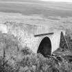
Photographs and Off-line Digital Images |
AN 6029 |
List C Survey |
General view. |
1975 |
Item Level |
|
|
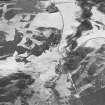
Photographs and Off-line Digital Images |
D 40348 |
RCAHMS Aerial Photography |
Oblique aerial view centred on the remains of rig with buildings, enclosures, road bridge and farmsteading adjacent, taken from the NW. |
8/2/1999 |
Item Level |
|
|
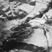
Photographs and Off-line Digital Images |
D 40350 |
RCAHMS Aerial Photography |
Oblique aerial view centred on the remains of buildings and enclosures with road bridge, rig and farmsteading adjacent, taken from the NW. |
8/2/1999 |
Item Level |
|
 |
On-line Digital Images |
SC 1651616 |
List C Survey |
General view. |
1975 |
Item Level |
|
 |
On-line Digital Images |
SC 1688305 |
RCAHMS Aerial Photography |
Oblique aerial view centred on the remains of rig with buildings, enclosures, road bridge and farmsteading adjacent, taken from the NW. |
8/2/1999 |
Item Level |
|
 |
On-line Digital Images |
SC 1716471 |
RCAHMS Aerial Photography |
Oblique aerial view centred on the remains of buildings and enclosures with road bridge, rig and farmsteading adjacent, taken from the NW. |
8/2/1999 |
Item Level |
|


