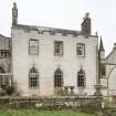
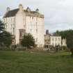
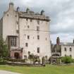
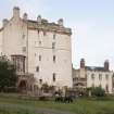
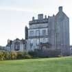
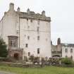
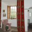
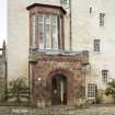
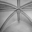
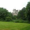
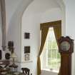
Accessibility

Font Size

100% 150% 200%

Background Colour

Default Contrast
Close Reset

Delgatie Castle

Castle (Medieval), Tower House (16th Century)

Site Name Delgatie Castle

Classification Castle (Medieval), Tower House (16th Century)

Alternative Name(s) Delgaty Castle

Canmore ID 19251

Site Number NJ75SE 4

NGR NJ 75445 50532

Datum OSGB36 - NGR

Permalink http://canmore.org.uk/site/19251

Ordnance Survey licence number AC0000807262. All rights reserved.
Canmore Disclaimer. © Bluesky International Limited 2025. Public Sector Viewing Terms

Toggle Aerial | View on large map

Digital Images

detail of painted ceiling.
detail of painted ceiling.detail of painted ceiling.detail of painted ceiling.detail of painted ceiling.Ground floor. Kitchen from east.Ground floor. Corridor to east of kitchen, vaulting and carved heads.Ground floor. Dining room from west.1st floor. Drawing room from north west.1st floor. Ante-room from south west.East wing from south west.Main tower and east wing from south.Entrance gates to courtyard from south.West wing including dummy dovecot and screen wall  from south.View from south west.Ground floor. Staircase. Detail of gunloop window on internal wall.Ground floor planMain tower and east wing from south west.Dummy dovecot and screen wall from south west.Delgatie Castle. Interior. Detail of corbel head in library.Delgatie Castle. Interior. Detail of inscription in library.Oblique aerial view of Delgatie Castle, looking SSE.Interior view of Delgatie Castle showing detail of ceiling painting in tower bedroom.Delgatty Castle Turriff Aberdeenshire, General Views of Painted CeilingDelgatty Castle Turriff Aberdeenshire, General Views of Painted CeilingDelgatty Castle Aberdeenshire, General Survey Overlap No. 1Delgatty Castle Aberdeenshire, General Survey Overlap No. 2Delgatty Castle Aberdeenshire, General Survey Overlap No. 2Delgatty Castle Aberdeenshire, General Survey Overlap No. 3Delgatty Castle Aberdeenshire, General Survey Overlap No. 3Delgatty Castle Aberdeenshire, General Survey Overlap No. 4Delgatty Castle Aberdeenshire, General Survey Overlap No. 5Delgatty Castle Aberdeenshire, General Survey Overlap No. 5Delgatty Castle Aberdeenshire, DetailsDelgatty Castle Aberdeenshire, DetailsDelgatie Castle, NJ75SE 4, Ordnance Survey index card, RectoDelgatie Castle. Interior. View of hall inside front door.Delgatie Castle. Interior. Detail of corbel head in library.Oblique aerial view centred on the country house, dovecot, and remains of the chapel with the farmhouse, farmsteading and walled garden adjacent, taken from the S.Oblique aerial view centred on the country house, dovecot, and remains of the chapel, taken from the NW.detail of painted ceiling.detail of painted ceiling.Main tower and east wing from south west.Main tower from north west.Main tower from north.Main tower and north wing from north east.East wing from north east.Ground floor. Staircase from west.1st floor. Drawing room from ante-room to east.Main tower and east wing from south west.1st floor. Morning room from west.2nd floor mezzanine. 'Tulip room'.View from south westMain entrance from south.Ground floor. Corridor. Detail of gunloop.Delgatie Castle. Interior. Detail of groined vault in library.Delgatie Castle. Interior. Detail of corbel head in library.Field visit, Vista from Delgatie Castle towards wind farm from N, Greeness Wind Farm, AberdeenshireView of east end of Delgatie Castle from south west.Interior view of Delgatie Castle showing niche with buddha in Drawing Room in tower.Delgatty Castle Turriff Aberdeenshire, General Views of Painted CeilingDelgatty Castle Turriff Aberdeenshire, General Views of Painted CeilingDelgatty Castle Turriff Aberdeenshire, General Views of Painted CeilingDelgatty Castle Turriff Aberdeenshire, General Views of Painted CeilingDelgatty Castle Aberdeenshire, DetailsDelgatie Castle. Interior. Detail of inscription in library.Oblique aerial view centred on the country house, dovecot, and remains of the chapel, taken from the WSW.detail of painted ceiling.Ground floor. Kitchen from west.Ground floor. Chapel to west of entrance hall from west.Ground floor. Entrance hall from west.1st floor mezzanine. 'Solar'/ library. Detail of fireplace.1st floor. Drawing room from north east.2nd floor. 'Prince de Bourbon' bedroom. Fireplace.3rd floor mezzanine. Painted chamber.3rd floor. Library.Ground floor. Corridor. Detail of carved heads and datestone.Delgatie Castle. Interior. View of niche in chapel.Oblique aerial view of Delgatie Castle, looking NW.Oblique aerial view of Delgatie Castle, looking S.Field visit, Delgatie Castle from NE, Greeness Wind Farm, AberdeenshireField visit, Delgatie Castle from NE, Greeness Wind Farm, AberdeenshireDelgatty Castle Turriff Aberdeenshire, General Views of Painted CeilingDelgatty Castle Turriff Aberdeenshire, General Views of Painted CeilingDelgatty Castle Aberdeenshire, General Views Delgatie Castle. Interior. Detail of corbel head in library.Oblique aerial view centred on the country house, dovecot, and remains of the chapel, taken from the SE.detail of painted ceiling.Detail of painted ceiling, Delgatie Castle.Fourth floor. Painted chamber. Ceiling.General view from south west.Main tower and east wing from south west.View from north west.East wing from south west.Ground floor. Dining room (chapel) from east.Staircase recess between first and second floor.1st floor mezzanine. 'Solar'/ library from south.1st floor mezzanine. 'Solar'/ library from north west.1st floor mezzanine. 'Solar'/ library. Detail of carved stone head corbel.General view from south west.3rd floor mezzanine. North room. Detail of fireplace.

First 100 images shown. See the Collections panel (below) for a link to all digital images.

Administrative Areas

  • Council Aberdeenshire
  • Parish Turriff
  • Former Region Grampian
  • Former District Banff And Buchan
  • Former County Aberdeenshire

Archaeology Notes

NJ75SE 4.00 75445 50532

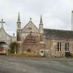
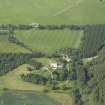
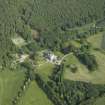
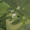
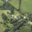
(NJ 75445 50532) Delgatie Castle (NR)

Chapel (NR) (Remains of)

OS 6" map, (1959)

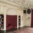
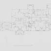
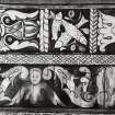
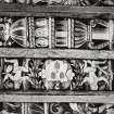
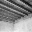
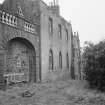
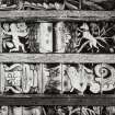
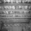
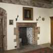
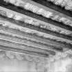
One of a group of four contemporary Aberdeenshire castles (Craig, Gight, and Towie Barclay are the others), almost certainly the work of the same master-mason. Probably dating between 1570 and 1579 as indicated by dates over a fireplace and on the E side of the wing respectively.

It is supposed that there was an earlier castle here: Lyons (1910) suggests that some walls of an earlier tower may have been incorporated, and Hay (1955) believes that the castle was rebuilt in 1346.

The authorised name form is 'Delgatie Castle' (information from OS and in letter from J Hay, {owner}).

W D Simpson 1930; A W Lyons 1910; SHR nd.

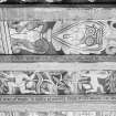
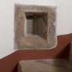
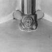
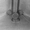
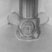
Only the S wall of the chapel remains, 4.0m long. Situated on the E end of the castle and level with the front face. It is of stone and in a good state of repair, the arch being blocked up. An inscribed tablet is set in the wall above the arch.

OS Reviser (T G Reeves) 8 August 1955.

Architecture Notes

NJ75SE 4.00 75445 50532

NJ75SE 4.01 75162 50685 Home Farm

NJ75SE 4.02 75566 50456 Lady Mary's Well

NJ75SE 4.03 75542 50602 Bridge

NJ75SE 4.04 75473 50654 Dovecot

NJ75SE 4.05 75494 50621 Foresters Cottage (Laundry)

NJ75SE 4.06 c.754 506 Site Cancelled. See NJ75SW 102

NJ75SE 4.07 c.753 505 Site Cancelled. See NJ75SW 44

NJ75SE 4.08 c.750 509 Gates and Garden Cottages

NJ75SE 4.09 75217 50855 Garden Walls

NJ75SW 44 NJ 73272 50397 Greengate Lodge

NJ75SW 102 NJ 74822 50995 Birchwood (North Lodge)

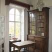
Date: c.1570 with later additons.

Activities

Photographic Survey (5 July 1949)

Photographic survey by the Ministry of Public Buildings and Works in July 1949.

Photographic Survey (1954)

Photographic survey by the Scottish National Buildings Record in 1954.

Photographic Survey (April 1955)

Photographic survey by the Scottish National Buildings Record in 1954.

Field Visit (1 May 2011 - 1 November 2011)

Cultural Heritage assessment for the proposed Greeness wind farm development. The assessment forms part of an Environmental Statement. The Cultural Heritage assessment identifies all historic environment features within the development area (through desk-based assessment and field survey), and key external receptors up to 10km from the proposed development. An assessment of the direct and indirect impacts of the development on these features is included.

Farmstead depicted as roofed on First Edition Ordnance Survey, now in ruins. No associated remains were discovered within the area.

Information from OASIS ID: cfaarcha1-207671 (H Tweedie) 2011

Photographic Survey (27 June 2012)

Photographed on behalf of the Buildings of Scotland publications.

RCAHMS (2012)

References

MyCanmore Image Contributions


Contribute an Image

MyCanmore Text Contributions