
Following the launch of trove.scot in February 2025 we are now planning the retiral of some of our webservices. Canmore will be switched off on 24th June 2025. Information about the closure can be found on the HES website: Retiral of HES web services | Historic Environment Scotland
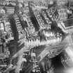
Dundee, Fish Street


General View (Period Unassigned)
Site Name Dundee, Fish Street
Classification General View (Period Unassigned)
Canmore ID 192337
Site Number NO43SW 652
NGR NO 40325 30106
NGR Description From NO 40307 30069 to NO 40342 30147
Datum OSGB36 - NGR
Permalink http://canmore.org.uk/site/192337


- Council Dundee, City Of
- Parish Dundee (Dundee, City Of)
- Former Region Tayside
- Former District City Of Dundee
- Former County Angus
Fish Street is depicted on the 1st edition OS 1:2500 scale map (1862-1881) and has since been demolished. Its course ran between Green Market and Yeaman Shore. The buildings of Whitehall Street and Whitehall Crescent now stand on its location.
Information from RCAHMS (SC) 5 March 2008.

