
Following the launch of trove.scot in February 2025 we are now planning the retiral of some of our webservices. Canmore will be switched off on 24th June 2025. Information about the closure can be found on the HES website: Retiral of HES web services | Historic Environment Scotland
Castle Of King Edward


Castle (Medieval)
Site Name Castle Of King Edward
Classification Castle (Medieval)
Alternative Name(s) King Edward Castle; Kinnedar Castle; Kineddar; Kinedard Castle; Kinedyne Castle
Canmore ID 19231
Site Number NJ75NW 1
NGR NJ 7220 5618
Datum OSGB36 - NGR
Permalink http://canmore.org.uk/site/19231


- Council Aberdeenshire
- Parish King Edward
- Former Region Grampian
- Former District Banff And Buchan
- Former County Aberdeenshire
NJ75NW 1 7220 5618
(NJ 7220 5618) Castle of King Edward (NR) (Remains of)
OS 6" map, Aberdeenshire, 2nd ed., (1902)
King Edward Castle: The ruins of what was probably a castle of the period between 1200 and 1300. The name associates it with Edward and his invasion, but it is believed to be a corruption of a much older name - Kinedar.
The castle seems to have been built by the Comyns, and was probably dismantled by Bruce, afterwards passing through many hands. Its appears to have been re-built by Lord Forbes early in the 16th century.
D MacGibbon and T Ross 1887-92.
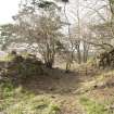
From the ground plan that remains, the castle appears to have belonged exclusively to the 13th century. Its enclosing walls had no angle towers.
The castle was protected on the south by the Burn of King Edward; on the east and west the sides were precipitous, and on the NW angle a deep ditch was dug which severed the neck of the peninsula.
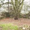
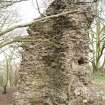
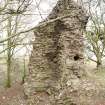
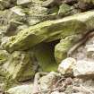
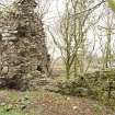
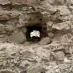
The ditch was spanned by a drawbridge which served a gateway, a massive portion of the base of which is the most conspicuous remaining fragment of the castle.
Within the courtyard can still be traced the rooms and towers of the castle. Three chambers flanked either side of the courtyard, and at the east end, opposite the gate, the two sides were closed by a chamber of quite large dimensions.
Foundations for that part of the building that did not rest on solid rock were found down the face of the promontory. Carved stones etc from the castle are preserved at Castleton Farm.
J Godsman 1952.
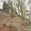
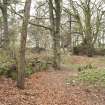
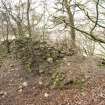
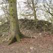
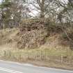
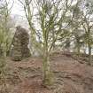
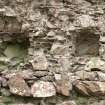
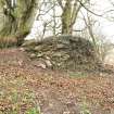
The remains of this castle, as described above, consist of fragments of walling now from 0.5m - 5.0m high, with the outline of a rectangular courtyard in the centre. The ditch on the NW side is more likely to be a natural, rather than an artificial, gully. The Castle Hill is now much overgrown, and the remains of the castle are further obscured by piles of rubble, apparently spoil from excavations. One stone said to be from the castle was seen inserted in the steading wall at Castleton; there are others now obscured or hidden by extension to the steading.
Revised at 1/2500.
Visited by OS (WDJ) 23 September 1964; Information from Mr W Sharp, farmer, Castleton.
Identified as motte.
P A Yeoman 1988.
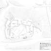
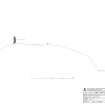
Measured Survey (April 2012)
RCAHMS surveyed Castle of King Edward in April 2012 producing a site profile at a scale of 1:250.
Field Visit (16 March 2012)
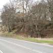
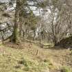
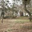
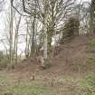
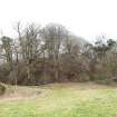
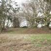
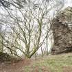
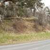
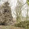
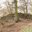
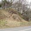
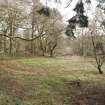
The castle of King Edward is built on a rocky promontory some 28m in height that overlooks the north bank of the King Edward Burn, a tributary of the Deveron. The public road from Banff to Turrif now runs directly past its W side and over the modern bridge (NJ75NW 56), but the previous bridging point lay on the E side, and is an indication of its strategic position on an important N-S route way. This earlier bridge, probably of 18th century date, still stands less its parapets (NJ75NW 55). The castle is not a motte and only the ditch can be construed as an earthwork and that appears to relate directly to the stone castle, which appears to be essentially of one phase.
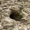
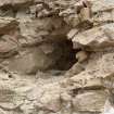
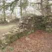
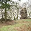
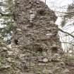
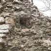
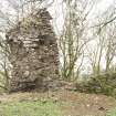
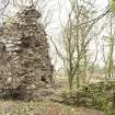
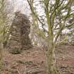
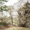
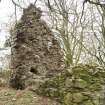
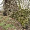
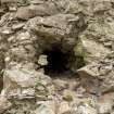
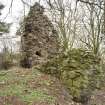
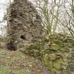
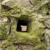
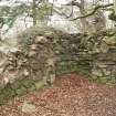
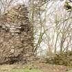
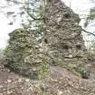
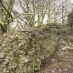
The castle is defended on the NW by a ditch 8m deep and 24m in breadth and by steep natural drops on all the other side, creating a level area, some 55m from NW to SE by 40m transversely. The curtain wall is set some 5m back from the edge of the ditch to allow space for the towers that defend it, and comprises a lime-mortared wall some 2m in thickness, most of the facings of which have been robbed, except on the rear, but there is enough there to indicate that there was a tallis at the base of the external face of the wall that projected at least 0.7m. No curtain wall survives on the eastern arc, although a terrace some 4m in width may be traced immediately SE of the N corner. The base of part of the SW curtain, about 6m in length, stills stands on a rocky outcrop that has ensured its survival, unlike the adjacent parts that have fallen away. One fallen fragment of wall lies down the slope on the SE to suggest that there was a wall along the riverside too, although this may derive from one of the buildings at this end. Quarries on the S by the modern bridge and at the NE corner have removed parts of the curtain and others structures at these points. Substantial mortared footings on the SW end of the NW wall suggest the presence of a tower at this corner, and the quarry at the NE end may mark the location of another at the N corner. The standing remains of the NW curtain include what appears to be a square tower still standing to some 6m in height and measuring 3.3m across internally within walls 2m thick, of which the SW side is best-preserved, indicating there was a basement and two floors supported by square joists, the holes of which are visible in the NE side of the tower. The tower stands on one side of the entrance gate of the castle, indicated by a square bar slot, 0.25m across, that runs within the interior of the curtain wall to a depth of 3m from the opening in the wall, and suggests a gate of double width. Running down into the basement of the tower there is a stone-lined slop drain, suggesting that the kitchens lay immediately SE of the tower. This may account for the narrow wall 0.8m in thickness that runs between the tower and the range to the SE, but is not tied in to either.
The buildings of the castle were arranged around a courtyard which reflects the wedge shaped-area of the promontory, narrowing towards the SE. The great hall lay on the NE and extended some 24m from NW to SE by about 8m transversely within walls 1.4m in thickness that still stand to as much as 2m in height at the NW. A rounded space in the WNW corner, 1m in diameter, appears to have been a newel stair, suggesting the basement was used as a store for a first-floor hall, there being only one demonstrable opening in the wall on the SW at its SE end. On the other side of the yard there was a building of two unequal compartments in proportions of 2:1, measuring 22.5m from ESE to WSW by 5.5m transversely within walls about 1m in thickness, no facings being visible. A third building stood in the space between the two on the SE, aligned from NE to SW, some 12m in overall length, whose SE side was destroyed by quarrying, and elsewhere by footings partly obscured by demolition debris. An L-shaped robber trench and lumps of masonry on the NW corner of the court suggest there was a major rectangular building at this location, some 16m by 8m internally, possibly a tower-house, but it has been thoroughly robbed except for a length of wall, 5m long by 2m thick, at right angles to the NW curtain on the SW. Only one feature appears is demonstrably of later phase and that is the cross-wall, 0.8m thick, that runs from the hall-house on the NNE across the yard to abut the two-compartment building on the SW, making a private area on the SE of it. Post-dating the castle period, there is a leveled area for a tennis court that occupies the courtyard, measuring 25 from E to W by 10m transversely. The farmer at Castleton Farm reported that a previous owner called Runciman constructed the tennis court in the 19th century.
There is nothing on the face of it to suggest later occupation than the 14th century, except a reused, quirked roll-molding that was found in the walls of the mill building situated immediately the NE of the old bridge (NJ75NW 55). The layout of the castle buildings compares well with the manor site at Grantully (NN85SE 87).
Visited by RCAHMS (PD, HS, JB and IA) 16 March 2012
Measured Survey (March 2012)
RCAHMS surveyed Castle of King Edward in March 2012 producing a plan of the castle at a scale of 1:250.
Measured Survey (15 March 2012)
RCAHMS surveyed Castle of King Edward on 15 March 2012 producing a detail plan of the tower at a scale of 1:100.

