
Pricing Change
New pricing for orders of material from this site will come into place shortly. Charges for supply of digital images, digitisation on demand, prints and licensing will be altered.
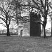
Uphall, Middleton Hall, Dovecot


Dovecot (Period Unassigned)
Site Name Uphall, Middleton Hall, Dovecot
Classification Dovecot (Period Unassigned)
Alternative Name(s) Middleton Hall Policies; Doo'cot
Canmore ID 192195
Site Number NT07SE 25.02
NGR NT 0623 7149
Datum OSGB36 - NGR
Permalink http://canmore.org.uk/site/192195


- Council West Lothian
- Parish Uphall
- Former Region Lothian
- Former District West Lothian
- Former County West Lothian
NT07SE 25.02 0623 7149
A rectangular dovecot is depicted on the 1st edition of the 6-inch map (Linlithgowshire, 1856, sheet 6) some 150m SSE of Middleton Hall.
Information from RCAHMS (DE), July 2001.

