
Brouster


Building(S) (Period Unassigned), Enclosure (Period Unassigned), Farmstead (Period Unassigned), Head Dyke(S) (Post Medieval)(Possible), Structure(S) (Period Unassigned)
Site Name Brouster
Classification Building(S) (Period Unassigned), Enclosure (Period Unassigned), Farmstead (Period Unassigned), Head Dyke(S) (Post Medieval)(Possible), Structure(S) (Period Unassigned)
Canmore ID 190405
Site Number HU25SE 61
NGR HU 25921 51616
Datum OSGB36 - NGR
Permalink http://canmore.org.uk/site/190405


- Council Shetland Islands
- Parish Walls And Sandness
- Former Region Shetland Islands Area
- Former District Shetland
- Former County Shetland
HU25SE 61 2593 5162
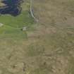
A farmstead comprising one unroofed building, two roofed buildings, one of which is arranged around a courtyard, and two enclosures, two separate buildings, one roofed and one unroofed, two unroofed structures, an enclosure and what may be two phases of head-dyke are depicted on the 1st edition of the OS 6-inch map (Orkney & Shetland (Shetland) 1882, sheet xlvi).
Five unroofed buildings, two partially roofed buildings, two roofed buildings, five enclosures and the head-dykes are shown on the current edition of the OS 1:10000 map (1973).
Information from RCAHMS (SAH), 22 May 2001.
Field Visit (16 June 2010)
This farmsteading developed from a 19th century U-plan arrangement of buildings around a S-facing yard. This is depicted on the 1st edition of the OS 6-inch map (Shetland 1882, Sheet XLVI), but by the beginning of the 20th century, the 2nd edition of the map (1903, Sheet XLVI) shows that this arrangement had been heavily modified. Since then, further changes have been made, including the removal of redundant buildings and the addition of new ones.
Of particular note are the remains of what may be the earliest cottage, which would probably have stood at the NW corner of the original U-plan range, but is now part of the western of two principal ranges. The surviving cottage wall includes a fireplace and what may either be a window or a cupboard. The present E range incorporates a farmhouse of one and a half storeys with a symmetrical frontage on the E, which includes a central entrance and flanking windows on the ground floor, attic skylights and an upstairs fireplace in the S gable. The upper floor only extends as far N as a partition just N of the door. To the N of the door there is a large blocked fireplace in the rear wall and a small stone lintelled window. There is a doorway through the N gable, which itself shows signs of incorporating an early single-storey gable with a steep pitch. To the S, the farmhouse has been extended one and a half storeys but showing a low pitched earlier raggle of a building that has probably been entirely rebuilt. There is an entrance and flanking windows in its E face, a fireplace, cupboard and upstairs fireplace in the S gable, and a small window close to the N end of the rear wall. The rear wall also contains the remains of two dormer windows. A small garden lies immediately S of the farmhouse.
Within the extent of the farm as defined by the stone walls depicted on the 1st edition map there are numerous remains that illustrate the long history of land-use at Brouster. Details of individual structures, ranging in date from the prehistoric period to modern times, are noted elsewhere in Canmore, but in addition to these there are numerous clearance cairns, generally on the W side of the farm, low terraces marking the edges of former cultivation, and fragmentary boulder walls and stony banks, few of which indicate any sense of coherent pattern.
Visited by RCAHMS (SPH) 16 June 2010.

