
Following the launch of trove.scot in February 2025 we are now planning the retiral of some of our webservices. Canmore will be switched off on 24th June 2025. Information about the closure can be found on the HES website: Retiral of HES web services | Historic Environment Scotland
Balquhain Castle


Castle (Medieval)
Site Name Balquhain Castle
Classification Castle (Medieval)
Alternative Name(s) Mains Of Balquhain; Castle Of Balquhain
Canmore ID 19022
Site Number NJ72SW 5
NGR NJ 73157 23603
Datum OSGB36 - NGR
Permalink http://canmore.org.uk/site/19022


- Council Aberdeenshire
- Parish Chapel Of Garioch
- Former Region Grampian
- Former District Gordon
- Former County Aberdeenshire
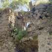
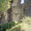
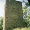
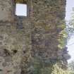
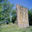
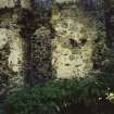
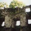
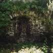
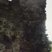
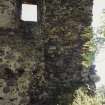
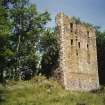
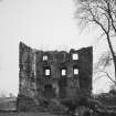
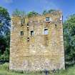
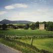
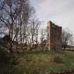
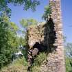
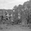
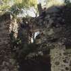
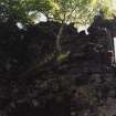
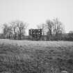
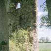
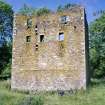
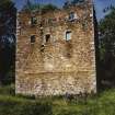
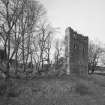
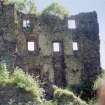
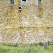
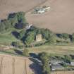
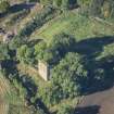
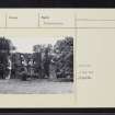
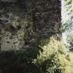
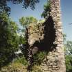
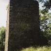
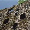
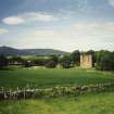
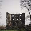
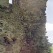
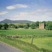
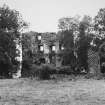
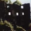
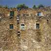
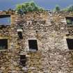
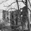
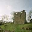
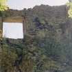
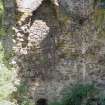
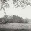
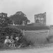
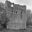
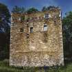
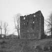
Castle of Balquhain, 15th century; rebuilt 1530. A grand Leslie seat, somewhat reduced but impressive in the scale of enclosure and the height of its brooding tower. Queen Mary stayed here in 1562 during her pursuit of the Gordons. The castle had been rebuilt a generation before for Sir William Leslie, although the blank lower walls (6ft thick) and the vaults of the great keep are clearly early. This is now split in two, although still standing to four storeys.
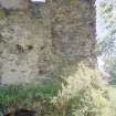
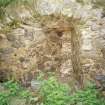
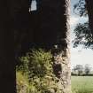
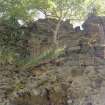
Of the 200 feet of frontage of outbuildings, only part of a round tower and overgrown foundations survive.
Taken from "Aberdeenshire: Donside and Strathbogie - An Illustrated Architectural Guide", by Ian Shepherd, 2006. Published by the Rutland Press http://www.rias.org.uk

NJ72SW 5 73157 23603
(NJ 7315 2361) Castle of Balquhain (NR)
OS 6" map, (1959)
For datestone of 1677 (possibly from the castle) built into (adjacent) Balquhain Mains, see NJ72SW 67.01.
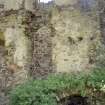
Balquhain Castle: The massive and impressive remains of a quadrangular keep, probably originally of the 15th century, destroyed in 1526 rebuilt in 1530 on much the same lines. The lower parts of the walls, probably original, are extremely thick with deep recesses and narrow loops. The barmkin wall encloses the highest part of a knoll and some of the outbuildings can still be traced.
The castle belonged to the Leslies, Barons of Balquhain, and it was here that Queen Mary spent the night before the Battle of Corrichie in 1562. It was burnt by the Duke of Cumberland in 1746.
D MacGibbon and T Ross 1887-92; W D Simpson 1936.
'Balquhain Castle' (information from Mr I W Strachen, Mains of Balquhain) mainly as described and planned by Simpson (1936).
Revised at 1/2500.
Visited by OS (ISS), 16 July 1973.
Photographic Survey (June 1962)
Photographic survey of Balquhain Castle, Aberdeenshire in 1962.
Measured Survey (1998)
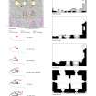
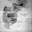
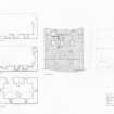
RCAHMS undertook a measured survey of Balquhain Castle in June 1998. Four phased floor plans and an elevation drawing were produced at 1:100. The drawings were redrawn in ink before final preparation in graphics vector software. They were published at the reduced scale of 1:200 (RCAHMS 2007, fig. 8.44).
Measured Survey (June 2001)
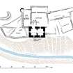
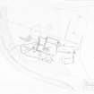
RCAHMS undertook a measured survey of Balquhain Castle in June 2001. A site plan was produced at 1:250 including the tower-house and the surrounding buildings. The drawing was redrawn in ink before final preparation in graphics vector software and published at the reduced scale of 1:500 (RCAHMS 2007, fig. 8.43).
Field Visit (17 May 2001)
NJ72SW 5 7315 2360
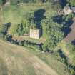
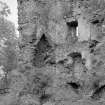
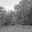
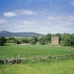
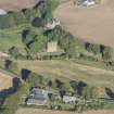
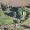
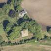
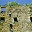
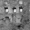
Balquhain Castle occupies a terrace on the W of the Strathnaterick Burn and comprises a group of buildings around a courtyard, including a late medieval chamber-block, a first-floor hall, another substantial building, some outbuildings and a terraced garden. In so far as they can be closely dated, the buildings range in date from the 15th century to the late 16th century.
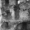
The primary structure is the crenellated chamber-block, to which the hall range was added on the W. A fore-stair in the return between them is an addition, possibly at the same time that a third floor was added to the chamber-block. Another building was added on the NNE gable of the chamber-block, and in the late 16th century the hall-range was extended and a turret added on the W corner. The courtyard was subsequently enclosed by the addition of another building on the WNW and a wall across the open side on the NNE. There are several other structures outside the courtyard that fit less easily into this sequence, including a terraced garden on the S on the chamber-block. Set into the slope of the river terrace, this was accessible via a path from an entrance in the middle of the SSW wall of the hall-range. The outbuildings on the N may have provided stabling and stores, but too little survives to be certain of their use or date. Indeed these structures impede access to the courtyard, which suggests they postdate the occupation of the castle.
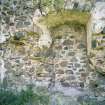
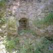
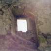
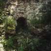
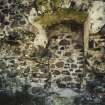
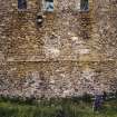
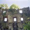
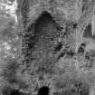
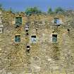
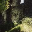
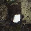
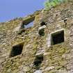
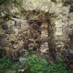
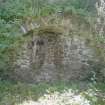
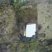
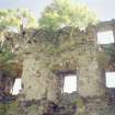
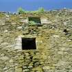
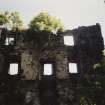
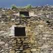
The chamber-block has a vaulted basement and rises to two stories with a crenellated wall-top. It measures 14m from NNE to SSW by 9.2m transversely over walls 1.8m in thickness. The basement is sub-divided into two stone-vaulted chambers and is entered from a ragged gap in the W wall of the S chamber, from which access to the N chamber was provided via an opening in the partition. Each chamber is lit by slit windows. The first floor was apparently a hall, heated by a fireplace in the NNE wall, and lit by two blocked openings on the ENE, of which that to the N was larger in order to light the dais end of the hall. This has a relieving arch and its base cuts into the string-course at first floor level, while the smaller window is centrally placed and slightly narrower. The lack of any wall surviving on the SW and NW above the basement leaves open other options in terms of lighting. It may also be presumed that there was a first-floor entrance on the WNW. The second floor, which was accessible from a newel stair in the NNW corner, has a timber floor and presumably contained private chambers. The three windows on the ESE, with a garderobe leading off the middle opening, are all secondary and the original arrangements are not known. The later addition of a third floor to the chamber-block has preserved the original crenellated parapet in the walls. The third floor provided further private apartments. The only features visible at this level are two window lights and a garderobe chamber in between them on the ESE, and a chamber in the wall-thickness on the SSW lit by a small window.
The construction of a hall on the W of the chamber-block may have replaced in stone a largely timber predecessor. The lack of any kitchen in the chamber-block or the new hall indicates that there was a separate structure for this purpose. The hall, which lies at right angles to the chamber-block, measures 16.2m by 8.6m transversely overall and has walls 1.4m thick. There are two ground-floor entrances, one in the return between the chamber and the hall, and the other in the middle of the SSW wall, providing access via a path to a terraced enclosure, or garden. A splayed opening towards the WNW end of the NNE wall may have been for a window light, but otherwise windows are notable by their absence at this level in the surviving masonry. The thickness of the wall and the lack of windows suggest a first-floor hall above basement stores. Subsequently the building was partitioned into two compartments by a stone wall midway along the interior, blocking the entrance on the SSW. It is presumed that the WNW gable was rebuilt at this time; its wall is only 0.8m in thickness and a there is a turret at the SW angle. This is probably of late 16th century date, incorporating a window light in the turret decorated with a quirked roll-moulding. A secondary rectangular stair-turret provides access to the first floor via a turnpike stair in the return between the hall and the chamber-block; no traces of the original access to the first-floor survive, but may be presumed to have been via an external stair. The WNW wing, which abuts the hall-range, measures 15.2m by 6m within walls 1m thickness. It has an entrance in its ESE wall opening into the courtyard, but no features remain that distinguish the function of the building, although a kitchen block is clearly required.
Although Balquhain is first documented as a site with a tower and fortalice in 1545 (Reg Magni Sig Reg Scot 1984c, 734), it has characteristics that make it likely to be somewhat earlier including the large rectangular chamber-block with crenellations. The estate of Balquhain first appears as a barony in 1511 (Reg Magni Sig Reg Scot 1984b, 775-6), but it was the eponymous possession of Sir William Leslie of Balquhain as early as 1460 (Reg Magni Sig Reg Scot 1984, 157), a blood relative of the lord of Leslie of that Ilk. The castle was apparently destroyed in 1526, and rebuilt in 1530 (MacGibbon and Ross 1887-92). Queen Mary spent the night here before the Battle of Corrichie in 1562, but the castle has been abandoned since the Duke of Cumberland burnt it in 1746, and was already on a downward social spiral after the move to Fetternear by Count Leslie in the 1690's (W D Simpson 1936). The house is described as an 'old seat of the Leslyes of Balquhoyn' in 1724 (Macfarlane 1906-8).
Visited by RCAHMS (PJD), 17 May 2001.
D MacGibbon and T Ross 1887-92; W MacFarlane 1906-8; W D Simpson 1936; Reg Mag Sig 1984.

