
Pricing Change
New pricing for orders of material from this site will come into place shortly. Charges for supply of digital images, digitisation on demand, prints and licensing will be altered.
Gruting


Chapel (Period Unassigned), Head Dyke (Post Medieval), Township (Period Unassigned)
Site Name Gruting
Classification Chapel (Period Unassigned), Head Dyke (Post Medieval), Township (Period Unassigned)
Canmore ID 190199
Site Number HU24NE 58
NGR HU 277 490
NGR Description Centred on HU 277 490
Datum OSGB36 - NGR
Permalink http://canmore.org.uk/site/190199


- Council Shetland Islands
- Parish Sandsting
- Former Region Shetland Islands Area
- Former District Shetland
- Former County Shetland
HU24NE 58 centred on 277 490
See also:
HU24NE 15 HU 2775 4910 Chapel; Burial-ground
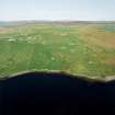
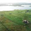
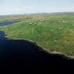
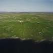
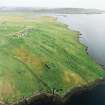
A township comprising twelve unroofed buildings, one partially roofed building, twenty-seven roofed buildings, one of which is annotated Methodist Chapel (Wesleyan), five unroofed structures, thirty-seven enclosures and a head-dyke is depicted on the 1st edition of the OS 6-inch map (Orkney & Shetland (Shetland) 1882, sheet xlvii). Twenty-two unroofed buildings, three partially roofed buildings, fifteen roofed buildings, thirty-one enclosures and the head-dyke are shown on the current edition of the OS 1:10000 map (1973).
Information from RCAHMS (SAH) 30 May 2001
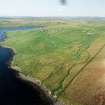
Field Visit (10 June 2010)
This township was not recorded in detail on the date of visit. However, noted within its southern part (in addition to the buildings HU24NE 202, 203 and 205), were a possible oval enclosure (HU 27695 49079), a shed or hut (HU 27721 49101), another at HU 27704 49022, and several lengths of ruined stone wall, some probably the remains of enclosures.
Visited by RCAHMS (GB) 10 June 2010.

