
Clevigarth


Head Dyke (Post Medieval), Township (Post Medieval)
Site Name Clevigarth
Classification Head Dyke (Post Medieval), Township (Post Medieval)
Canmore ID 189381
Site Number HU42NW 45
NGR HU 426 271
NGR Description Centred HU 426 271
Datum OSGB36 - NGR
Permalink http://canmore.org.uk/site/189381


- Council Shetland Islands
- Parish Dunrossness
- Former Region Shetland Islands Area
- Former District Shetland
- Former County Shetland
HU42NW 45 centred 426 271
Se also:
HU42NW 14 HU 424 270 Settlement
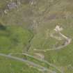
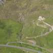
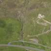
A township comprising nine unroofed buildings, seven of which lie close to burns and may be mills, one partially roofed building, three roofed buildings, nine unroofed structures, six enclosures and a head-dyke is depicted on the 1st edition of the OS 6-inch map (Orkney & Shetland (Shetland) 1882, sheet lxii). Seventeen unroofed buildings, four unroofed circular structures, five enclosures and the head-dyke are shown on the current edition of the OS 1:10000 map (1973).
Information from RCAHMS (SAH), 13 June 2001.
HU 4250 3350 - HU 4340 2550 A walkover survey in advance of refurbishment to the 11Kv hydro-electric line was undertaken in 1999. The following sites were identified:
HU 4271 2781 Stone and turf hill dyke.
HU 4277 2778 Large sub-rectangular structure/enclosure.
HU 4269 2776 Turf field dyke.
HU 4269 2774- Remains of 3 sub-rectangular structures.
HU 4268 2767
HU 4263 2742 Sub-rectangular structure.
HU 4257 2736 Circular planticrub.
Sponsor: Scottish Hydro-Electric plc.
B Simpson 2000.

