
Pricing Change
New pricing for orders of material from this site will come into place shortly. Charges for supply of digital images, digitisation on demand, prints and licensing will be altered.
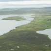
Yell, Houlland


Field System (Period Unassigned), Head Dyke (Post Medieval), Township (Period Unassigned)
Site Name Yell, Houlland
Classification Field System (Period Unassigned), Head Dyke (Post Medieval), Township (Period Unassigned)
Canmore ID 189208
Site Number HU58SW 24
NGR HU 501 801
NGR Description Centred on HU 501 801
Datum OSGB36 - NGR
Permalink http://canmore.org.uk/site/189208


- Council Shetland Islands
- Parish Yell
- Former Region Shetland Islands Area
- Former District Shetland
- Former County Shetland
HU58SW 24 centred on 501 801
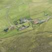
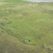
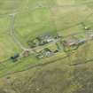
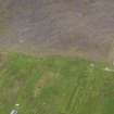
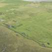
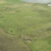
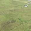
A crofting township comprising one unroofed building, twenty-eight roofed buildings, five unroofed structures, several enclosures and a head-dyke is depicted on the 1st edition of the OS 6-inch map (Orkney & Shetland (Shetland) 1881, sheet xxii). There are several areas of narrow strip fields within the township.
Eleven unroofed buildings, two partially roofed buildings, twenty-one roofed buildings, several enclosures and the head-dyke are on the current edition of the OS 1:10000 map (1973).
Information from RCAHMS (SAH) 3 July 2001
HU 5250 9450 - HU 4650 7950 A walkover survey in advance of refurbishment to the 11Kv hydro-electric line was undertaken in 2000. The following sites were identified:
HU 5088 8000 Planticrub.
Sponsor: Scottish Hydro-Electric plc.
B Simpson 2000

