
Nether Benzieclett


Farmstead (18th Century), Horse Engine Platform (19th Century), Observation Post (20th Century)
Site Name Nether Benzieclett
Classification Farmstead (18th Century), Horse Engine Platform (19th Century), Observation Post (20th Century)
Canmore ID 1890
Site Number HY22SE 55
NGR HY 28033 20580
Datum OSGB36 - NGR
Permalink http://canmore.org.uk/site/1890


- Council Orkney Islands
- Parish Sandwick
- Former Region Orkney Islands Area
- Former District Orkney
- Former County Orkney
HY22SE 55 28033 20580.
Although considerably altered, this is a good example of the simpler Orkney homestead which compares with the early Norse house of Iceland.
RCAHMS 1946.
Field Visit (7 May 2013)
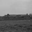
This traditional Orkney farmstead, which is now roofless, is comprehensively described in Alexander Fenton’s account (1978, 116-118), which is illustrated with a plan, two sections and an elevation taken by RCAHMS in 1968, when the building remained largely intact (ORD/3/1; G 96106 S). It is now in some danger of collapse.
The farmstead comprises two ranges, both facing SE, set along the SE side of a large rectangular enclosure. The NE range measures about 28m from NE to SW by a maximum of 6m transversely over roughly coursed faced flagstone walls that still stand for the most part to full height. Only the dwelling at the NE end retains a portion of its original flagstone and turf covered roof, together with the timber framework that supported it, but even this is now poorly anchored and has begun to cave in. Nevertheless, the four compartments and the two bed-nooks remain intact, while the press and the fireplace with its iron swey in the kitchen survive, despite the fact that both are blocked with debris. However, the timber partitions that subdivided the ben in the middle of the range are long gone, as are the five box beds that once stood within it, while the walls of the byre at the SW end have partly fallen.
The SW range has been built on the same orientation as the NE range but is set slightly further towards the SE. It measures about 32m from NE to SW by 5.5m transversely over roughly coursed faced flagstone walls that stand largely to wall-head height. The interior contains three compartments and there is an outshot at each end. The SW half of the range is narrower than the NE half, a reflection of its earlier construction as evidenced by the 1st edition of the OS 6-inch map (Orkney 1882, Sheet XCIV). This SW end contained a barn, and a horse-engine platform, measuring about 10m in diameter, lies attached to the SE side of the building. The NE end of the range appears to have contained a byre, and two slab-built stalls project from the inner face of the NW wall, while two single doorways and a small window punctuate the SE facade. In the compartment between the byre and the barn there are the remains of a large rectangular flagstone bin which appears to have been a grain store. The outshot at the NE end of the range was a cart-shed.
The large rectangular yard measures roughly 80m from NE to SW by 40m transversely over flagstone walls. There is a gateway immediately SW of the SW range and a small rectangular enclosure, measuring roughly 13m from NNW to SSE by 8m transversely over flagstone rubble walls, lies within its W corner. This appears to have been accessed from the SSE. All that now remains of a probable garden enclosure that stood adjacent to the SE side of the NE range are its wall-footings.
There is also a WWII observation post situated immediately SE of the NE range. This measures about 3m from NE to SW by 2m transversely over flagstone rubble walls thinly rendered with concrete. Its flat roof remains intact and the building, which contains a large rectangular gun-port low down in the SE wall and a small rectangular aperture near the top left corner, was accessed by a central doorway on the NW. Its lintel has the following inscription outlined in capital letters in the wet cement: ‘Air Raid Shelter’. This was probably established to help protect the disused airfield of Skeabrae (HY22SE 59) situated some 600m to the W.
The farmstead is depicted roofed on the 1st and 2nd editions of the OS 6-inch map, together with the yards to the front and rear of both buildings. However, the small enclosure situated in the W corner of the large enclosure first appears on the 2nd edition of the map (Orkney 1903, Sheet XCIV).
Visited by RCAHMS (ATW) 7 May 2013.
Orkney Smr Note
A good example of a simple longhouse, with two dwelling-house units and a byre in line, roughly on an E-W axis.
For full description, see Fenton 1978, p117-8.
Information from Orkney SMR [n.d.]

