
Pricing Change
New pricing for orders of material from this site will come into place shortly. Charges for supply of digital images, digitisation on demand, prints and licensing will be altered.
Upcoming Maintenance
Please be advised that this website will undergo scheduled maintenance on the following dates:
Thursday, 9 January: 11:00 AM - 3:00 PM
Thursday, 23 January: 11:00 AM - 3:00 PM
Thursday, 30 January: 11:00 AM - 3:00 PM
During these times, some functionality such as image purchasing may be temporarily unavailable. We apologise for any inconvenience this may cause.
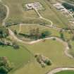
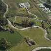
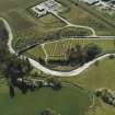
Inverurie, Keithhall Road, Old Inverurie Churchyard


Burial Ground (Period Unassigned), Church (12th Century)
Site Name Inverurie, Keithhall Road, Old Inverurie Churchyard
Classification Burial Ground (Period Unassigned), Church (12th Century)
Alternative Name(s) Inverurie, Old Parish Church; Inverurie Cemetery; Chapel Of Inverurie
Canmore ID 18885
Site Number NJ72SE 15
NGR NJ 77982 20644
NGR Description Centred NJ 77982 20644
Datum OSGB36 - NGR
Permalink http://canmore.org.uk/site/18885


- Council Aberdeenshire
- Parish Inverurie
- Former Region Grampian
- Former District Gordon
- Former County Aberdeenshire
Old Kirkyard, Keithhall Road. 'The walls of the old kirk were demolished about the beginning of the 19th century and the
kirkyard dykes built with the stones.' The Bass (motte) and Little Bass (bailey) surgically separated in 19th century. Robert Bruce lay sick in Inverurie on the eve of his victory of Barra at Yule, 1308. Four Pictish stones (including unique single horse), 17th-century stones (eg Walter Innes of Ardtannes, 1616) and ball-capped gatepiers. Mortsafe tackle now
in Inverurie Museum (above Library). On grave of Helen Bruce who died in her 28th year:
O, painted piece of living clay;
Man be not proud of thy short day;
For like a lily fresh and green
She was cut down, and no more seen.
Taken from "Aberdeenshire: Donside and Strathbogie - An Illustrated Architectural Guide", by Ian Shepherd, 2006. Published by the Rutland Press http://www.rias.org.uk

NJ72SE 15 centred 77982 20644
For Pictish Symbol Stones and cross-incised stones (NJ 7802 2062), Bass of Inverurie (NJ 7809 2059) and Inverurie Cemetery (centred NJ 7815 2055), see NJ72SE 11.00, NJ72SE 13, NJ72SE 138 respectively.
For (successor and present) Parish Church of St Andrew (NJ 7763 2111), see NJ72SE 132.
(NJ 7800 2064) Church (NR) (site of)
OS 6" map, Aberdeenshire, 2nd ed., (1928)
The chapel of Inverurie, first mentioned about 1190, occupied the same site as the later parish churches.
J Davidson 1884.
The parish church formerly stood near the north-west corner of the churchyard, but it was removed in 1775. Portions of the foundations are sometimes located during grave-digging.
J Ritchie 1911.
The site of the old church shown on the OS 25" plan agrees with the position pointed out by Mr Gray. At this point there is a slight platform, too amorphous for survey, which may represent the foundations of the old church or may possibly be associated with later graves. The area is at present in use as a cemetery. A tombstone at NJ 7802 2062, dated 1616, is said by Mr Gray to have been built into the old church wall.
Visited by OS (NKB) 9 March 1964; Information from Mr A L Gray, 131 High St, Inverurie.
(Location cited as NJ 7800 2059). Inverurie Churchyard: old ball-capped gate-piers and good collection of 17th century stones, notably that to Walter Innes of Ardtannes (1616).
[Photographic imagery listed].
NMRS, MS/712/35.
(GRC/AAS nos. NJ72SE 110 and NJ72SE 127 ). The Chapel of Inverurie (removed 1775) is recorded as GRC/AAS NJ72SE 15.
Coffin-shaped granite mortsafe 6ft (1.83m) long, 1ft 6ins (0.46m) broad at the head-end, 9-10ins (229 to 254mm) thick.
J Ritchie 1912; NMRS, MS/712/72.
Publication Account (1977)
Inverurie parish church, along with others, was granted to Lindores Abbey by Earl David of Huntingdon at the end of the twelfth century, a grant mentioned in a papal bull of 1195 (Davidson, 1878, 25). Until 1775 the parish church stood in the northwest corner of the churchyard down by the Bass. There is little indication what material the building was constructed of, although an early seventeenth century entry in the burgh records refers to the townsmen bringing thatch to the church (Davidson, 1878, 197). From 1660 Kirk Session references to the dilapidated condition of the structure increase, with a bulwark being constructed at the end of the century to help save the fabric from the ravages of the flooding Don (Black, 1942, no page no.). A new parish church was not built in the High Street until 1775, with that building being replaced by the present South (now St. Andrew's) Parish Church in 1842. Although early this century portions of the foundations of the pre-1775 church were uncovered by gravedigging (Ritchie, 1911, 343), the only above-ground indication of the church site is a slight platform, described by the Ordnance Survey as too amphorous for survey, which might represent the church or be associated with later graves (Ordnance Survey Record Cards, Reference NJ 72 SE 15).
Information from ‘Historic Inverurie: The Archaeological Implications of Development’ (1977).

