Bass Of Inverurie
Motte And Bailey (Medieval), Mace (Period Unassigned), Pitcher (14th Century), Unidentified Pottery (Medieval), Worked Object(S) (Flint)(Period Unassigned)
Site Name Bass Of Inverurie
Classification Motte And Bailey (Medieval), Mace (Period Unassigned), Pitcher (14th Century), Unidentified Pottery (Medieval), Worked Object(S) (Flint)(Period Unassigned)
Alternative Name(s) The Bass; Little Bass; Old Inverurie Churchyard; Inverurie Cemetery
Canmore ID 18883
Site Number NJ72SE 13
NGR NJ 7809 2059
Datum OSGB36 - NGR
Permalink http://canmore.org.uk/site/18883
- Council Aberdeenshire
- Parish Inverurie
- Former Region Grampian
- Former District Gordon
- Former County Aberdeenshire
NJ72SE 13 7809 2059
(NJ 7809 2059) The Bass (NR) Castle (NR) (site of).
(NJ 7814 2060) Little Bass (NAT)
OS 6" map, Aberdeenshire, 2nd ed., (1928)
For Pictish Symbol Stones (NJ 7802 2062), Old Inverurie Churchyard (NJ 7800 2064) and Inverurie Cemetery (centred NJ 7815 2055), see NJ72SE 11.00, NJ72SE 15, NJ72SE 138 respectively.
For flint-working site (NJ c. 781 205), see NJ72SE 49.
For adjacent trial excavation, see NJ72SE 158.
Part of a 14th century green glazed pitcher bearing a bearded mask, and a base fragment of brown glazed ware, were given to National Museum of Antiquities of Scotland (NMAS) in 1918. Accession nos. MEA 344-5.
Proc Soc Antiq Scot 1919.
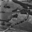
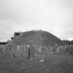
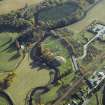
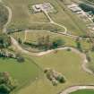
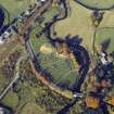
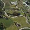
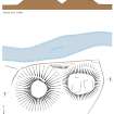
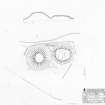
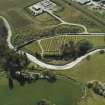
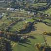
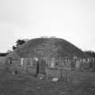
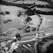
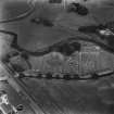
The Bass of Inverurie is a natural mound about 50ft high with a summit area of about 60ft diameter, converted to a motte by the scarping of its sides, and the excavation of a ditch around it and the Little Bass, which was the bailey. The ditch is now filled up but grave-digging has shown it to have been about 10 feet wide and at least 8 feet deep.
During the excavation in 1883 the remains of an oaken gangway up the south face of the motte were discovered. After alterations in 1883 the Little Bass now measures about 20 feet high with a top about 95 feet in length from east to west by about 75 feet in breadth.
There were hereditary Constables of Inverurie Castle in the 12th century, and 14th century pottery has been found during grave-digging in the ditch.
J Davidson 1886; W D Simpson 1924.
'The frequent discovery of flint implements, cores and flakes all around the Norman castle suggests a Neolithic occupation of the site, and a fine polished stone adze' suggests a Bronze Age occupation. The adze is now in the museum there.
W D Simpson 1943.
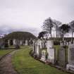
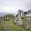
The Bass and Little Bass are now separate ornamental features within a cemetery (NJ72SE 138), but were connected before the alterations in 1883 (information from Dr W D Simpson, King's College, Old Aberdeen).
Revised at 1/2500.
The worked flints were found during extensions to the cemetery around the foot of the Bass about 25 years ago, and some are still in the possession of Dr Simpson.
The 'adze' in Inverurie Museum is a 'cushion' mace-head (Acc. No. AH 3) and was found near the Bass in 1928 by John Robertson (information from Dr A A Woodham, Clava, Cunninghill Road, Inverurie).
Visited by OS (NKB) 10 March 1964.
(Location cited as NJ 7809 2059). This natural mound has been converted to a motte by the scarping of its sides and the excavation of a ditch around it. The ditch is now infilled, but grave-digging has revealed its original dimensions.
[Air and ground photographic imagery, and newspaper/periodical references listed].
NMRS, MS/712/36.
(GRC/AAS NJ72SE 128). Little Bass: NJ 7814 2060.
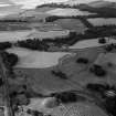
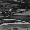
Air photography: CUCAP XD 15, flown 15 July 1958.
NMRS, MS/712/72.
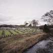
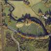
(Classified as Motte-and-Bailey Castle; Worked Flints; Cushion Mace-head; Pottery). The earthwork castle known as the Bass of Inverurie now lies in the churchyard of Inverurie, about 120m ESE of the site of the old parish church of Inverurie (NJ72SE 15). It is the only castle site in Strath Don that takes the 'classic' form of a motte and bailey. The castle provided the administrative centre of the earldom of Garioch during the late 12th and early 13th centuries.
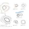
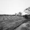
The motte at the Bass is a conical hillock, which currently stands about 12m high and about 18m across the top. The bailey comprises an oval flat-topped mound, measuring 30m from E to W by 23m transversely across its top, and standing only about 5m above the surrounding ground-level. It is reported that the site was landscaped in the late 19th century, at which time a path was cut between the motte and the bailey, and the top of the motte was levelled. Two slightly raised rectangular platforms occupy the surface of the bailey. Both are aligned from N to S, measuring 17m and 11m in length respectively by 9.5m transversely. They may represent the location of buildings such as a hall and chamber.
Visited by RCAHMS (PJD) 27 September 2001.
J Davidson 1878; A O Curle 1919; K J Stringer 1985.
Scheduled as 'The monument known as The Bass and Little Bass, motte-and-bailey castle... now visible as substantial earthworks.'
Information from Historic Scotland, scheduling document dated 5 March 2008.
In 2018, Scheduled Monument Consent approved relocation of SM74 (four symbol stones) to within the grounds of SM99 (Bass and Little Bass Motte) and their housing within a glass case display.
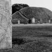
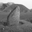
The four Class I Pictish symbols stones were previously located 100m west northwest of their present location and are now in a glass display case on The Bass and Little Bass, motte-and-bailey castle (Scheduled Monument SM99). This is located within Inverurie Cemetery.
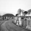
The stones are believed to have been previously built into the walls of the old parish church, which stood in the northwest corner of the adjacent cemetery. The kirk went out of use in 1775, its walls were used as a source to construct or repair the dykes of the kirkyard in the early 19th century. Three of the symbol stones were later removed from the dykes and while another was rescued when the walls were being constructed. The four symbol stones are now in a glass display case, known as and arranged (from left to right) as; Inverurie numbers 1, 2, 3 and 4.
Publication Account (1977)
Little is actually known of the castle of Inverurie. In the late twelfth century Malcolm, son of Bartoli, held the castle as constable for David, Earl of Huntingdon (Davidson, 1878, 2). Up to the date of its abandonment it was the chief seat of the lords of the Garioch. The discovery of early fourteenth century lottery on the motte, or the Bass, as it more popularly was known, suggest that it was a castle site to at least the period of the Wars of Independence. Bass and Little Bass (the bailey) were connected before excavations and alterations were undergone in 1883. During the excavations the remains of an oaken gangway up the south side were discovered. The circumference of the Bass is 510 feet (155m) at the bottom and 240 feet (73m) at the top (Anon, n. d., no page number), with the surrounding ditch estimated to have been up to ten feet (3m) wide and at least eight feet (2m) deep (Simpson, 1924, 41).
Information from ‘Historic Inverurie: The Archaeological Implications of Development’ (1977).


