
Pricing Change
New pricing for orders of material from this site will come into place shortly. Charges for supply of digital images, digitisation on demand, prints and licensing will be altered.
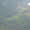
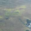
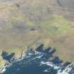
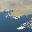
Unst, Collaster


Farmstead (Period Unassigned)
Site Name Unst, Collaster
Classification Farmstead (Period Unassigned)
Canmore ID 188816
Site Number HP50NE 36
NGR HP 57934 07457
Datum OSGB36 - NGR
Permalink http://canmore.org.uk/site/188816


- Council Shetland Islands
- Parish Unst
- Former Region Shetland Islands Area
- Former District Shetland
- Former County Shetland
HP50NE 36 5791 0745
A farmstead comprising four unroofed buildings, two of which are long buildings with subdivisions, one roofed building and three enclosures is depicted on the 1st edition of the OS 6-inch map (Orkney and Shetland (Shetland) 1882, sheet v). Three unroofed buildings and three enclosures are shown on the current edition of the OS 1:10000 map (1973).
Information from RCAHMS (SAH) 25 January 2001
Field Visit (January 1970 - December 1991)
A survey of deserted settlements in Unst by June Owers. The survey includes photographs, sketches and historical information.
Srp Note (27 September 2011)
A plan of Collaster was sketched by June Owers in her survey of abandoned settlements on Unst (1990).
Information from RCAHMS (BRW) 27 September 2011
Excavation (10 July 2017 - 19 July 2017)
HP 57934 07457 (Collaster) and HP 58201 07219 (Bool) Let Da Stons Spaek: Uncovering the stories of Unst’s silent homes is a project combining archaeology, archive research and family/oral history based in the abandoned township of Collaster, Westing on Unst, the most northerly of the Shetland Islands. It is a collaboration led by Unst Partnership, with Unst Heritage Centre, Baltasound Junior High School and the local community, supported by professional archaeologists. In 2017 the project undertook a 10 day excavation, 10–19 July, at two abandoned farmsteads within Collaster: Bool and Easterhouse. Twelve trenches were excavated with the assistance of volunteers and school children. In total there were 43 volunteers, with an additional 24 visitors to the site.
At Bool the trenches revealed details about the construction of the farmhouse and buildings, including the raising and extension of the (earlier?) barn and byre and the paved floor of the southern extension. Evidence for a timber floor or collapsed upper floor was also found in the main farmhouse. The drain in front of the house was exposed, alongside the ‘briggstens’ (paving) extending along the front wall. The location of the peat stack was identified within the walled enclosure at the front of the house. A number of finds were recovered from the midden, including a wooden awl, stone weight and metal-soled shoe, alongside 19th- and 20th-century pottery. Within the barn finds included a doll’s tea cup, a glass bead and a slate stylus.
At Collaster the trenches investigated a possible earlier building associated with the earliest structures on the site. Evidence for the wall was slight; however, there was a possible foundation identified running N/S, although this was not excavated. A trench in the byre to the W revealed no floor remaining, with topsoil directly above natural subsoil. However, a number of finds were recovered from Collaster including clay pipe and 19th-century pottery.
Archive: NRHE and Unst Heritage Centre (intended)
Funder: Heritage Lottery Fund
Elizabeth Jones and Daniel Rhodes – Unst Partnership
(Source: DES, Volume 18)

