
Inverurie, General


Burgh (Medieval), Town (Medieval) - (Modern)
Site Name Inverurie, General
Classification Burgh (Medieval), Town (Medieval) - (Modern)
Canmore ID 18866
Site Number NJ72SE 104
NGR NJ 7738 2157
NGR Description Centred on NJ 77 21
Datum OSGB36 - NGR
Permalink http://canmore.org.uk/site/18866


- Council Aberdeenshire
- Parish Inverurie
- Former Region Grampian
- Former District Gordon
- Former County Aberdeenshire
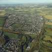
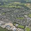
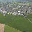
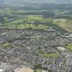
INVERURIE. A lang toon squeezed between the meanders of the Urie as it nears its confluence with the Don and the low, rolling hills of the Garioch (in the words of the 'Inverurie Poet', William Thom, ... 'whaur creepin Ury greets its mountain cousin Don'). It began as a swampy medieval caput, its motte-and-bailey castle now split and tonsured in the cemetery. Across the Don, Port Elphinstone (named after Robert Elphinstone of Logie) was the terminus of the Aberdeen Canal (1807-54) and saw the real lift-off of Inverurie. Entrepot and banking centre for the agricultural expansion of the Garioch, the grain girnal of Aberdeenshire, an important stop on the new turnpike, communications became enshrined in its now
defunct railway works, which are still visible (Harlaw Road). Now a thriving, bustling market town of some 19th-century grace at its centre and considerable oil-related expansion to the north. Farming, industry, oil - a blend which epitomises
eastern Aberdeenshire life at the beginning of the 21st century.
Taken from "Aberdeenshire: Donside and Strathbogie - An Illustrated Architectural Guide", by Ian Shepherd, 2006. Published by the Rutland Press http://www.rias.org.uk

NJ72SE 104 77 21.
King William in 1178x1182 gave Inverurie to his brother earl David, and by 1195 it was a burgh. It became a royal burgh by charter in 1558.
G S Pryde 1965
This paper offers a review of recent archaeological investigations in Inverurie and places them in the historical context of the 12th century Lordship of Garioch. Results of excavations in the Stanners, close to the Bass of Inverurie, suggest that this was not the original location of the burgh. The probably site of the burgh on the modern High Street has so far failed to provide any evidence for medieval activity. This negative result is explained by reference to the likely nature and function of the burgh in the 12th and 13th centuries. It is suggested that burghs like Inverurie have little in common with the better-known trading burghs and should be treated as components of a medieval lordship.
S Carter 1999.
There is no change to the existing record.
Information from RCAHMS (JRS), 3 April 2001.
Photographic Survey (February 1954 - March 1954)
Photographs of buildings in Inverurie, Aberdeenshire, by the National Buildings Record Scottish Council in February and March 1954.

