
Following the launch of trove.scot in February 2025 we are now planning the retiral of some of our webservices. Canmore will be switched off on 24th June 2025. Information about the closure can be found on the HES website: Retiral of HES web services | Historic Environment Scotland
Dundee, Kirk Street Cda


Slab Block(S) (20th Century)
Site Name Dundee, Kirk Street Cda
Classification Slab Block(S) (20th Century)
Alternative Name(s) Dundee, Kirk Street Central Development Area
Canmore ID 188438
Site Number NO33SE 374
NGR NO 37583 31478
Datum OSGB36 - NGR
Permalink http://canmore.org.uk/site/188438


- Council Dundee, City Of
- Parish Dundee (Dundee, City Of)
- Former Region Tayside
- Former District City Of Dundee
- Former County Angus
Commission And Contract (1967)
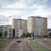
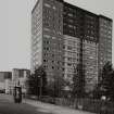
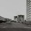
Four sixteen-storey tower blocks built as public housing as part of the central development of the Kirk St area. The blocks, which were constructed by Dundee Borough Council, contained a total of 480 dwellings. Construction was approved by committee in 1967. The contractor for the development was Scotcon.
Glendinning and Methusius 1994
Partial Demolition (1967 - 2009)
Two of the multi-storey blocks (Sharps Court and Yeamans Court) are now demolished. The date of demolition is unknown. Adamson Court and Elders Court remain. It is not known whether the two blocks were demolished at the same time.
Photographic Record (September 1982)
Photo taken by Dr Miles Glendinning for research purposes.

