
Pricing Change
New pricing for orders of material from this site will come into place shortly. Charges for supply of digital images, digitisation on demand, prints and licensing will be altered.
Castle Fraser


Standing Stone(S) (Prehistoric)
Site Name Castle Fraser
Classification Standing Stone(S) (Prehistoric)
Alternative Name(s) Castle Fraser Estate; Castle Fraser Policies; Balgorkar
Canmore ID 18720
Site Number NJ71SW 4
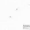
NGR NJ 7174 1250
Datum OSGB36 - NGR
Permalink http://canmore.org.uk/site/18720


- Council Aberdeenshire
- Parish Cluny
- Former Region Grampian
- Former District Gordon
- Former County Aberdeenshire
NJ71SW 4 7174 1250
See also NJ71SW 3.
(NJ 7174 1250 ) Standing Stones (NR)
OS 6" map, (1959)
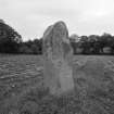
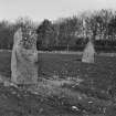
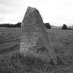
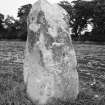
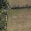
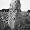
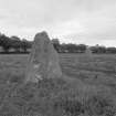
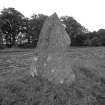
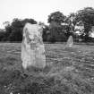
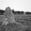
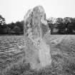
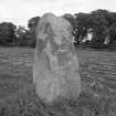
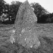
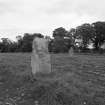
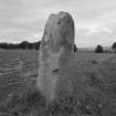
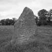
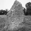
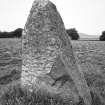
Two grey granite standing stones, nearly 7ft above ground, of 12ft 9ins and 8ft 9ins girth respectively, are situated in a field approximately 500ft east of a stone circle (NJ 7149 1253) and close to the road on the west of Castle Fraser (NJ 722 125).
F R Coles 1901.
These two standing stones are situated 13m apart within a cultivated field about 220m E of the recumbent stone circle NJ71SW 3. The NE stone is a grey granite pillar speckled with quartz and measures 1.73m in breadth from ENE to WSW by 0.48m in thickness and 2.05m in height. The SW stone measures 0.88m in breadth from NW to SE by 0.55m in thickness and 1.8m in height. The respective alignments of the stones indicate the pair are unlikely to be the remains of a stone circle.
Visited by RCAHMS (ATW), 8 July 1999.
NJ 7 174 1250 In November 2005, a scatter of broken white quartzite pebbles was noted in ploughsoil in the area immediately to the NW of the pair of standing stones near Balgorkar/Castle Fraser recumbent stone circle (NJ71SW 4).

