
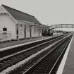
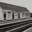
Dundee, Monifieth Station


Railway Station (19th Century) - (20th Century)
Site Name Dundee, Monifieth Station
Classification Railway Station (19th Century) - (20th Century)
Canmore ID 186540
Site Number NO43SE 150
NGR NO 49719 32286
Datum OSGB36 - NGR
Permalink http://canmore.org.uk/site/186540


- Council Angus
- Parish Monifieth (Angus)
- Former Region Tayside
- Former District City Of Dundee
- Former County Angus
Publication Account (2013)
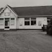
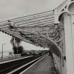
For the Dundee and Arbroath Railway in 1838, two small single-storey station houses very close to the track, like toll-houses with projecting gables from which to view approaching trains, and then activate the level crossing. A later timber platform building has been transferred from Carnoustie to Bo’ness, Falkirk (SRPS) there to become Birkhill station, with ironwork by Beath and Keay of Dundee. Signal box and footbridges.
M Watson, 2013

