
Pricing Change
New pricing for orders of material from this site will come into place shortly. Charges for supply of digital images, digitisation on demand, prints and licensing will be altered.
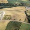
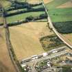
Broomend Of Crichie


Standing Stone(S) (Prehistoric)
Site Name Broomend Of Crichie
Classification Standing Stone(S) (Prehistoric)
Canmore ID 18654
Site Number NJ71NE 9
NGR NJ 779 193
Datum OSGB36 - NGR
Permalink http://canmore.org.uk/site/18654


- Council Aberdeenshire
- Parish Kintore
- Former Region Grampian
- Former District Gordon
- Former County Aberdeenshire
NJ71NE 9 779 193.
(B - NJ 7792 1959: NJ 7792 1948)
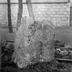
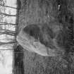
Standing Stone (NR) urn containing ashes found.
(C - 7792 1924) Standing Stone (NR)
OS 6" map, (1938)
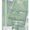
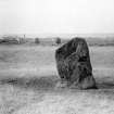
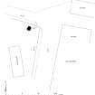
According to Maitland and other authorities a double line of stones about 20 yards (18.3m) apart extended from a point 450 yards south of the circle (NJ71NE 6) up to the circle, and on from there to the other circle (NJ71NE 7), an overall length of about 500 yards. Each side of the avenue would have contained about forty stones but only 3 remain.
The three remaining stones vary between 4 feet 6 inches (1.4m) and 6 feet (1.8m) in height, 2 feet 6 inches (0.76m) to 3 feet 8 inches (1.1m) in breadth, and 1 foot (0.3m) to 3 feet 3 inches (1m) in thickness. A cremation burial was found at the foot of each of stones B and C.
A fourth stone (A - NJ 7792 1960) was removed in 1851.
J Ritchie 1920.
In addition to the three stones mentioned by Ritchie (1920), a fourth stone, presumably the only one of the western side of the avenue remaining, was found at NJ 7790 1932.
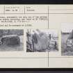
Surveyed and re-surveyed at 1/2500.
Visited by OS (RD) 10 March 1964.
This monument is situated in arable fields at an altitude of about 60m OD.
NMRS, MS/712/67, visited 4 September 1980.

