
Monkland Canal, Gartsherrie Hornock And Summerlee Branch, Coatbridge


Canal (19th Century)
Site Name Monkland Canal, Gartsherrie Hornock And Summerlee Branch, Coatbridge
Classification Canal (19th Century)
Alternative Name(s) Gartsherrie Iron Works; Gartsherrie Burn
Canmore ID 186520
Site Number NS76NW 66
NGR NS 7305 6550
NGR Description NS 7300 6511 to NS 7282 6615
Datum OSGB36 - NGR
Permalink http://canmore.org.uk/site/186520


- Council North Lanarkshire
- Parish Old Monkland (Monklands)
- Former Region Strathclyde
- Former District Monklands
- Former County Lanarkshire
NS76NW 66.00 7305 6551 to 7281 6601
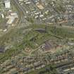
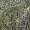
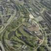
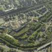
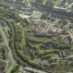
This branch canal, approximately one mile in length, was built to serve the Gartsherrie Iron Works.
J Lindsay 1968.
This canal was completed when the Gartsherrie and Summerlee Iron Works opened.
C McCutcheon 1993.
The Gartsherrie Burn was culverted in parts in order to allow the branch canal to be cut on its bed. Although this branch canal was originally planned as a waterway to serve coal mines, it had not been finished by 1830 when the Gartsherrie Iron Works were established by the Baird brothers at its terminus. The Summerlee Iron Works, set up in 1836, were also located by this canal.
G Hutton 1993.
This branch canal is clearly visible on the 1st edition of the OS 6-inch map (Lanarkshire 1864, sheet vii) and on the 2nd edition of the OS 6-inch map (Lanarkshire, sheets viiSE and viiNE). On the 2nd edition map the canal terminates at an earlier point, NS76NW 7281 6601, with chemical works situated over what appears to be the final stretch on the 1st edition map and an associated terminal basin (NS76NW 66.11).
In the North Lanarkshire Archives, Cumbernauld (Drumpellier Estate Papers, U1 08/16/6) is a letter of 26 June 1829 containing an account for making the Branch Canal, by that stage already completed. Another letter, dated 8 July 1831, refers to the canal as the Branch Cut.
Information from RCAHMS (MD) 10 January 2002.

