
Fullerton


Barrow (Prehistoric)
Site Name Fullerton
Classification Barrow (Prehistoric)
Alternative Name(s) Cairnhall; Foularton
Canmore ID 18637
Site Number NJ71NE 74
NGR NJ 78435 17972
Datum OSGB36 - NGR
Permalink http://canmore.org.uk/site/18637


- Council Aberdeenshire
- Parish Kintore
- Former Region Grampian
- Former District Gordon
- Former County Aberdeenshire
NJ71NE 74 78435 17972
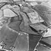
For other cropmark sites nearby seee:
NJ71NE 75 7838 1817 Fowlertown Cottage enclosure
NJ71NE 96 7836 1797 Fullerton pit-alignment
NJ71NE 97 781 184 Fullerton fort; ring-ditches
NJ71NE 98 7846 1798 Fullerton ring-ditch; cropmarks
NJ71NE 100 7830 1780 Fullerton enclosure
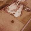
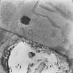
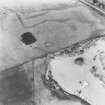
This circular enclosure is known from (rather faint) cropmarks and 'cannot be ruled out as henge-related'; Fullerton stone circle (NJ71NE 14) is situated close by to the NW. It is situated at an altitude of about 61m OD on a gravel terrace about 600m N of the River Don, measures less than 10m in diameter and is defined by a single broad ditch (with a possible break in the W sector).
A F Harding and G E Lee 1987.
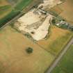
This circular enclosure is situated (among other cropmarks) in arable ground at an altitude of about 60m OD.
[Air photographic imagery listed.]
NMRS, MS/712/36.

