
Loudoun Hill


Natural Feature (Period Unknown)
Site Name Loudoun Hill
Classification Natural Feature (Period Unknown)
Canmore ID 185536
Site Number NS63NW 53
NGR NS 6084 3790
NGR Description NS centred on 6084 3790
Datum OSGB36 - NGR
Permalink http://canmore.org.uk/site/185536


- Council East Ayrshire
- Parish Loudoun
- Former Region Strathclyde
- Former District Kilmarnock And Loudoun
- Former County Ayrshire
NS63NW 53 6084 3790
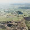
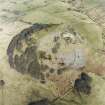
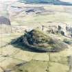
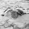
This volcanic core, which forms a prominent landmark above the River Irvine, has been recorded on oblique aerial photographs (RCAHMSAP 2003 and 1997). The Roman Road (RR6) runs to the S, Loudounhill Roman Fort (NS63NW 1) and two medieval battlefields (NS63NW 2 and NS63NW 6 ) also lie to the S across the River Irvine.
Information from RCAHMS (MMB) 26 February 2003

