
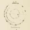
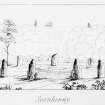
Sunhoney


Cup Marked Stone (Prehistoric), Recumbent Stone Circle (Neolithic) - (Bronze Age)
Site Name Sunhoney
Classification Cup Marked Stone (Prehistoric), Recumbent Stone Circle (Neolithic) - (Bronze Age)
Alternative Name(s) Seanhinny; Dunecht Estate
Canmore ID 18543
Site Number NJ70NW 55
NGR NJ 71592 05701
Datum OSGB36 - NGR
Permalink http://canmore.org.uk/site/18543


- Council Aberdeenshire
- Parish Midmar
- Former Region Grampian
- Former District Gordon
- Former County Aberdeenshire
NJ70NW 55 71592 05701.
(NJ 7159 0569) Stone Circle (NR)
OS 6" map, (1959)
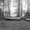
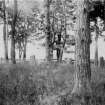
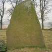
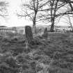
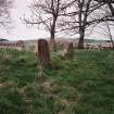
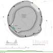
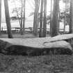
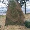
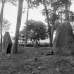
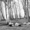
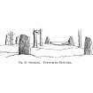
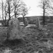
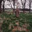
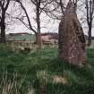
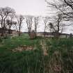
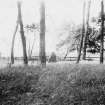
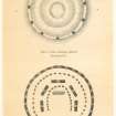
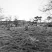
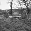
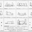
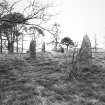
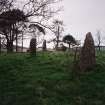
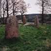
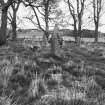
A complete stone circle of 87ft 6ins (26.7m) maximum diameter, consisting of a recumbent stone 17ft 4ins (5.3m) long, two pillars, and nine other standing stones, is situated in a small plantation a short distance to the north west of the farmhouse of Sunhoney.
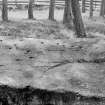
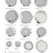
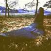
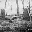
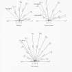
On what is at present the upper surface of the recumbent stone, are 31 cup marks, but as this stone appears to have fallen over on its inner side, it seems probable the marks were originally on the outer or southern face. There is also a similar cup on a fragment split off from the recumbent stones when it fell.
F R Coles 1900; J Ritchie 1918.
A recumbent stone circle as described above, except that only 7 cup marks are now evident on the recumbent stone and one mark on the broken off fragment.
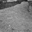
In addition to the circle of stones there is a grass-covered inner platform 7.0 metres in diameter by 0.3 metres high.
Re-surveyed at 1/2500.
Visited by OS (RD) 13 January 1965.
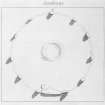
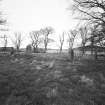
The monument is very well preserved recumbent stone circle, 25m in diameter, lying in an area bounded by a 19th-century plantation wall. The circle comprises 11 standing stones and the recumbent. The recumbent and one of the uprights bear cupmarks. Within the circle is a raised platform measuring some 7m across, probably the remains of a ring cairn.
Informtation from Historic Scotland, scheduling document dated January 1996.
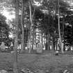
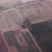
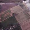
This stone circle is situated in a copse on a low summit at an altitude of about 125m OD. There is locally higher ground to the S. It has been disturbed by 19th century excavation but is otherwise well preserved.
(Additional bibliography cited).
NMRS, MS/712/64, visited May 1985.
Publication Account (1986)
A fine recumbent stone circle, 25.4 m in diameter, consisting of a recumbent, two flanking pillars and nine other standing stones, located on a well defined but low hill shoulder at 125 m OD. The recumbent has slumped and part of it has broken off; it bears 31 cup-marks. It is a fine-grained grey granite whereas all the other stones are a reddish granite or a gneiss. Traces of a low ring cairn can be seen in the interior. Charles Elphinstone Dalrymple dug into the ring in 1865 and found deposits of cremated bone and some fire-marked stones in the central space. A 'circular' cist with some fragments of a 'rude stone vessel' lay at the south side of the ring cairn. As at Loanhead of Daviot (no. 98), each circle stone stood in a little low cairn, although today the stones appear to be in a low bank; the circle may have undergone some restoration. The recumbent is aligned on the point at which the moon-rise is first visible above the hills to the south. The circular plan of Sun honey places it early in the development of such circles.
Information from ‘Exploring Scotland’s Heritage: Grampian’, (1986).
Publication Account (1996)
A fine recumbent stone circle, 25.4m in diameter, consisting of a recumbent, two flanking pillars and nine other standing stones, located on a well defined but low hill shoulder at 125 m OD. The recumbent has slumped and part of it has btoken off; it bears 31 cup-marks. It is a fine-grained grey granite whereas all the other stones are a reddish granite or a gneiss. Traces of a low ring cairn can be seen in the interior. Charles Elphinstone Dalrymple dug into the ring in 1865 and found deposits of cremated bone and some fire-marked stones in the central space. A 'circular' cist with some fragments of a 'rude stone vessel' lay at the south side of the ring cairn. As at Loanhead of Daviot (no. 98), each circle stone stood in a little low cairn, although today the stones appear to be in a low bank; the circle may have undergone some restoration. The recumbent is aligned on the point at which the moon-rise is first visible above the hills to the south. The circular plan of Sunhoney places it early in the development of such circles.
Information from ‘Exploring Scotland’s Heritage: Aberdeen and North-East Scotland’, (1996).
Field Visit (15 April 1998)
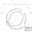
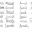
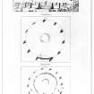
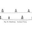
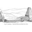
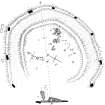
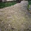
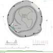
This grass-grown recumbent stone circle is situated within a small plantation of mixed woodland on the summit of a hill overlooking Sunhoney from the NW. It measures 25m in overall diameter and comprises the recumbent setting and nine orthostats set out around the perimeter of a low cairn; all the stones bar the recumbent on the SW (2) are upright, and this is broken into two pieces. The larger piece is a slab measuring 5.2m in length by 1.4m in breadth. This now lies face down, and its even summit is set flush with the leading faces of the two flankers. It cannot have fallen into this position and has evidently been moved, a clear indication that the ring has undergone some restoration, probably, as will be shown below, in the 18th century. Furthermore, its W tip is caught behind the W flanker, and cannot have been dragged back into this position when the flanker was in place. There are at least 28 shallow cups on the upturned surface of the larger piece of the recumbent, and one on the smaller fragment lying displaced immediately to its NW. The two flankers (1 & 3) are of a similar size and shape, standing about 2.1m and 2.2m high respectively, and the tops of the rest of the orthostats are roughly graded to reduce in height from the SW, though unusually the lowest is on the ESE (6). There is no equivalent reduction in the spacing of the stones, which are set out fairly evenly along the line of a low ring-bank. Externally the height of the ring-bank has been exaggerated by the cultivation of the surrounding ground, and it forms the leading edge of a low platform encircling a roughly circular cairn some 20m in diameter. Although no kerbstones are visible, the perimeter of this cairn is quite well defined, extending outwards on the SW to meet the back of the recumbent setting.
Visited by RCAHMS (JRS, ATW, IGP and KHJM) 15 April 1998
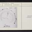
Measured Survey (14 February 2018)
Minor additions were made to the plan taken by RCAHMS in 1998. These included the low scarp behind the recumbent setting defining part of the SW flank of the internal cairn, segments of the low ring-bank between orthostats 7-8 and 11-12, and a reworking of the hollow resulting from Dalrymple’s excavation.
Visited by HES, Survey and Recording (ATW, AMcC), 14 February 2018.

