
Reedieleys


Cropmark(S) (Period Unknown), Pit(S) (Period Unassigned), Quarry (Period Unassigned)(Possible), Rig And Furrow (Medieval) - (Post Medieval), Ring Ditch (Period Unassigned)
Site Name Reedieleys
Classification Cropmark(S) (Period Unknown), Pit(S) (Period Unassigned), Quarry (Period Unassigned)(Possible), Rig And Furrow (Medieval) - (Post Medieval), Ring Ditch (Period Unassigned)
Canmore ID 184870
Site Number NO21SW 260
NGR NO 22718 10258
NGR Description NO centred on 22718 10258
Datum OSGB36 - NGR
Permalink http://canmore.org.uk/site/184870


- Council Fife
- Parish Auchtermuchty
- Former Region Fife
- Former District North East Fife
- Former County Fife
NO21SW 260 centred on NO 22718 10258
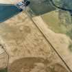
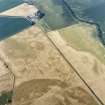
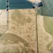
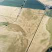
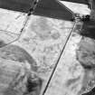
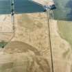
A scatter of pits, rig and what may be a quarry have been recorded as cropmarks on oblique aerial photographs to the WSW of Reedieleys farmsteading (NO21SW 118). The possible quarry describes a shallow C-shape from SW to NE and has very sharply defined edges. The rig is aligned from NNW to SSE, with furrows spaced about 10m apart, and forms the southern part of an extensive system of rig extending to the N (NO21SW 362).
Information from RCAHMS (DCC) 3 February 2004

