Accessibility

Font Size

100% 150% 200%

Background Colour

Default Contrast
Close Reset

Doon Hill

Palisaded Enclosure (Later Prehistoric)

Site Name Doon Hill

Classification Palisaded Enclosure (Later Prehistoric)

Canmore ID 184663

Site Number NT67NE 189

NGR NT 68577 75423

Datum OSGB36 - NGR

Permalink http://canmore.org.uk/site/184663

Ordnance Survey licence number AC0000807262. All rights reserved.
Canmore Disclaimer. © Bluesky International Limited 2025. Public Sector Viewing Terms

Toggle Aerial | View on large map

Digital Images

Aerial view of Doon Hill, taken from the SSW, centred on a cropmark of a rectilinear enclosure.  A cropmark of a possible palisaded enclosure, situated to the N, is visible in the centre left of the photograph.  A timber hall encloure, also to the N, is visible in the top left-hand corner of the photograph.
Aerial view of Doon Hill, taken from the SSW, centred on a cropmark of a rectilinear enclosure.  A cropmark of a possible palisaded enclosure, situated to the N, is visible in the centre left of the photograph.  A timber hall encloure, also to the N, is visible in the top left-hand corner of the photograph.Aerial view of Doon Hill, taken from the W, centred on a cropmark of a rectilinear enclosure.  A cropmark of a possible palisaded enclosure, situated to the N, is visible in the left-hand corner of the photograph.Oblique aerial view.Oblique aerial view centred on the cropmarks of the rectilinear settlement and other cropmarks with the timber halls and enclosure and the cropmarks of the possible enclosure adjacent, taken from the S.Oblique aerial view centred on the cropmarks of the rectilinear settlement and other cropmarks with the timber halls and enclosure and the cropmarks of the possible enclosure adjacent, taken from the WSW.Aerial view of Doon Hill, taken from the NNW, centred on a cropmark of a possible palisaded enclusure.  A cropmark of a rectilinear enclosure, situated to the S, is visible in the top centre of the photograph.  A timber hall encloure, situated to the N, is visible in the bottom left-hand corner of the photograph.Aerial view of Doon Hill, taken from the NW, centred on the cropmark of a rectilinear enclosure.  A cropmark of a possible palisaded enclosure, situated to the N, is visible in the bottom centre of the photograph.Aerial view of Doon Hill, taken from the SSW, centred on a cropmark of a rectilinear enclosure.  A cropmark of a possible palisaded enclosure, situated to the N, is visible in the centre left of the photograph.  A timber hall encloure, also to the N, is visible in the top left-hand corner of the photograph.Aerial view of Doon Hill, taken from the NE, centred on a cropmark of a possible palisaded enclosure.  A cropmark of a rectilinear enclosure, situated to the S, is visible in the centre left of the photograph.  A timber hall encloure, situated to the N, is visible in the bottom centre of the photograph.Aerial view of Doon Hill, taken from the NNW, centred on a cropmark of a possible palisaded enclusure.  A cropmark of a rectilinear enclosure, situated to the S, is visible in the top centre of the photograph.  A timber hall encloure, situated to the N, is visible in the bottom left-hand corner of the photograph.Aerial view of Doon Hill, taken from the NW, centred on a cropmark of a possible palisaded enclosure.  A cropmark of a rectilinear enclosure, situated to the S, is visible in the top centre of the photograph.Aerial view of Doon Hill, taken from the W.  A cropmark of a rectilinear enlcosure is visible in the bottom left hand corner of the photograph.  A cropmark of a possible palisaded enclosure is visible in the bottom centre.  A timber hall enclosure is visible in the centre left of the photograph.Aerial view of Doon Hill, taken from the NE, centred on a cropmark of a possible palisaded enclosure.  A cropmark of a rectilinear enclosure, situated to the S, is visible in the centre left of the photograph.  A timber hall encloure, situated to the N, is visible in the bottom centre of the photograph.Oblique aerial view centred on the cropmarks of the rectilinear settlement and cropmarks with the cropmarks of the possible enclosure adjacent, taken from the SSE.

Administrative Areas

  • Council East Lothian
  • Parish Dunbar
  • Former Region Lothian
  • Former District East Lothian
  • Former County East Lothian

Archaeology Notes

NT67NE 189 NT 68578 754424

Activities

Aerial Photographic Transcription (20 October 2008)

An interpretative transcription, or mapping, of information on oblique aerial photographs was produced on 20 October 2008.

Note (6 October 2022)

The location, classification and period of this site have been reviewed.

Aerial Photographic Transcription (11 October 2022)

An interpretative transcription, or mapping, of information on oblique aerial photographs was produced on 11 October 2022.

Aerial Photographic Interpretation (6 October 2022)

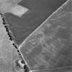
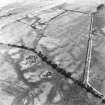
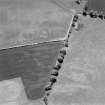
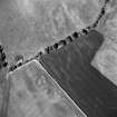
The E half of a palisaded enclosure has been recorded as cropmarking on oblique photographs (RCAHMSAP 1997, 2004) on level ground about 190m NE of Skaw Plantation. It measures about 16m from N to S by about 12m within a palisade trench about 0.5m broad. An entrance gap is visible on the E. An enclosed settlement been recorded about 40m S (NT67NE 45) and two forts (NT67NE 60 and 95) about 150m and 200m to the NW respectively.

Information from HES Archaeological Survey (F. Vermeij) 6 October 2022

References

MyCanmore Image Contributions


Contribute an Image

MyCanmore Text Contributions