
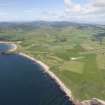
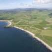
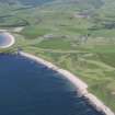
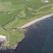
Southend, General


Village (Period Unassigned)
Site Name Southend, General
Classification Village (Period Unassigned)
Canmore ID 183826
Site Number NR60NE 31
NGR NR 6900 0843
NGR Description Centred NR 6900 0843
Datum OSGB36 - NGR
Permalink http://canmore.org.uk/site/183826


- Council Argyll And Bute
- Parish Southend
- Former Region Strathclyde
- Former District Argyll And Bute
- Former County Argyll
NR60NE 31 centred 6900 0843
Watching Brief (21 September 2009 - 24 September 2009)
This report describes the results of archaeological watching briefs undertaken during the refurbishment of an 11kv overhead power line at the south end of the Kintyre peninsula, Argyll. The refurbishment consisted of replacing several wooden poles which were either rotten or had split and inserting a few associated stays. Some of the poles were situated within an area where the surviving evidence of prehistoric occupation and usage was considered high, this area being defined on a map produced by the West of Scotland Archaeology Service (WoSAS). Another archaeologically sensitive area was around High Keil, at the south-west end of the power line.
The refurbishment was carried out by Scottish & Southern Energy, the watching briefs being undertaken by John Lewis of Scotia Archaeology between 21st and 24th September 2009.

