
Raich


Four Poster Stone Circle (Bronze Age)
Site Name Raich
Classification Four Poster Stone Circle (Bronze Age)
Canmore ID 18361
Site Number NJ64SW 1
NGR NJ 6187 4365
Datum OSGB36 - NGR
Permalink http://canmore.org.uk/site/18361


- Council Aberdeenshire
- Parish Forgue
- Former Region Grampian
- Former District Gordon
- Former County Aberdeenshire
NJ64SW 1 6187 4365.
(NJ 6187 4365) Stone Circle (NR)
OS 6" map, (1959)
A small stone circle set on a sharply-defined stony mound, now turf-covered.
The circle, only about 18' in diameter, is composed of blue whinstones, the settings of some of which suggested to Coles (1903) possible remains of cists. These lie on the north, close to the edge and are two earthfast blocks 19" high, an erect stone 4'2" high to the east and an earthfast block close beside it.
Four well-set stones still stand erect on the south arc, the most easterly being 4'8" high, the middle two, 3', and the most westerly 2'5".
F R Coles 1903.
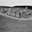
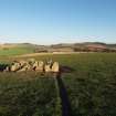
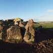
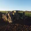
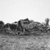
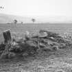
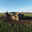
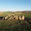
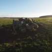
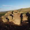
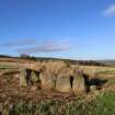
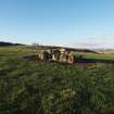
This is a good example of the type of monument known as a "four-poster"; it measures 4.3m NW-SE by 3.3m NE-SW overall.
The W corner has been destroyed by ploughing, but the rest survives in good order and comprises an upright stone in each of three corners with a straight kerb of boulders on edge between them. The N and E stones are both 1.4m high and the S is 1.1m. The kerb varies in height between 0.9m and 0.2m. There has been no attempt to level the site, nor are the stones set on a mound as described by Coles (1903). The interior is filled to a height of about 0.6m by turf-covered earth and stones (un-certainly original), with additional recent field clearance. One large loose boulder in the centre, 0.9m long, may be the missing NW block, whilst other boulders may be from the kerb.
Coles has misinterpreted displaced stones as the remains of cists.
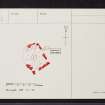
Resurveyed at 1:2500.
Visited by OS (ISS) 9 January 1973.
Field Visit (15 November 2018)
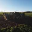
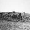
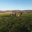
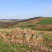
This cairn is situated in improved pasture at the rear of a narrow terrace on an E-facing slope overlooking Glen Dronach. It is rectangular on plan and measures 4.3m from NW to SE by 3.7m transversely. It is delimited on the S, E and N by three tall orthostats measuring from 1m to 1.28m in height, but the fourth on the W is missing. Although the E orthostat is the tallest, that on the N may have been decapitated and it is not certain that these stones were graded in height. In between them are large kerbstones – two on the SW, two on the SE and two on the NE - their configuration suggesting that the NE and SW sides of the cairn were constrained by four kerbstones, while the NW and SE sides were constrained by only three. The interior is filled with stones and boulders which rise 0.3 above the tallest of the orthostats. Many have been scratched by the plough and evidently result from field clearance. They completely obscure the make-up of the cairn.
The Rev. William Dingwall reported at the end of the 18th century that there were ‘the vestiges of several Druidical temples in the parish’ (Stat Acct, xii, 179*, 288), although neither he nor a later Minister of the parish, the Reverend James Cordiner (NSA 12, Aberdeenshire, 601), specifically refer to Raich. However, the cairn was duly noted as a ‘Stone Circle’ by the Ordnance Survey in 1867, who planned the three orthostats (Banffshire & Aberdeenshire 1872, Sheet XXII. 13) and described the monument as ‘a few irregularly placed stones: some standing on their ends, and some lying; supposed to have been a Druidical Temple’ (Name Book, Aberdeenshire, No. 31, p 38). Although Frederick Coles provided the first detailed plan (Coles 1903, 125-7), this emphasises the supposed circularity of the ‘very distinct and sharply defined mound’ upon which he perceived it to stand, as much as the stones themselves. His quotation of a diameter using the N and S stones suggests that he did not properly conceive of it as a rectangle, possibly on account of its similarity to Sheithen (NJ83SE 6) and less so to South Ythsie (NJ83SE 12), which he had plotted the previous year and which he believed to be analogous. James Ritchie’s photograph of April 1906 (HES AB2549), taken from the same perspective as Coles’ sketch, shows that the cairn was then much as it is today, while confirming the presence of the stony mound which is now wholly obscured by the clearance. Alexander Keiller also recognised its likeness to Sheithen (Keiller 1928, 12-13), commenting ‘that here we are not dealing with circles at all, although they have invariably hitherto been so described’. He thought they might be ‘the chambers of large cairns, of which nothing else now remains’ – a theory that has not met with acceptance (Keiller 1934, 4-5). Aubrey Burl, having classified the monument initially in terms of the stone setting, noted its internal cairn (Burl 1976, 353). Later he suggested that it could perhaps be best understood as a ‘hybrid’, possessing features in common with both Recumbent Stone Circles and Four-Posters (Burl 1988, 14-17, 96-7; 1995, 106; 1996, 196; 2000, 422) – a ‘transitional ring’ the evolution of which could have been driven by social change in the Bronze Age. This relationship with four-posters was accepted by John Barnatt (Barnatt 1989, 139, 299), but although small megalithic monuments are now recognised as a characteristic of the later Bronze Age in North-East Scotland, Raich may owe little or nothing to recumbent stone circles. However, as the earlier commentators have noted, its use of large kerbstones and orthostats does invite comparison with Sheithen.
Visited by HES, Survey and Recording (ATW, AMcC, KLG), 15 November 2018
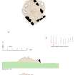
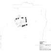
Measured Survey (15 November 2018)
HES surveyed Raich four poster stone circle with plane-table and alidade on 15 November 2018 at a scale of 1:50. GNSS data was also collected to record sections across the site. The resultant plan and sections were redrawn in vector graphics software..
Field Visit (12 November 2021)
The classification, location and period of this site record have been reviewed as part of record revision work carried out by HES Designations.
Visited by HES Designations R McDonald), 16 May 2022

