
Pricing Change
New pricing for orders of material from this site will come into place shortly. Charges for supply of digital images, digitisation on demand, prints and licensing will be altered.
Scheduled Maintenance Notice
Please be advised that this website will undergo scheduled maintenance starting on Thursday, 30th January at 11:00 AM and will last until Friday, 31st January at 10:00 AM.
During this time, the site and certain functions may be partially or fully unavailable. We apologise for any inconvenience this may cause.
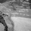
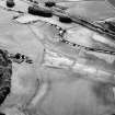
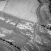
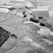
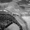
Legatesden


Cottage (Period Unassigned)
Site Name Legatesden
Classification Cottage (Period Unassigned)
Canmore ID 183243
Site Number NJ72NW 219
NGR NJ 7378 2581
Datum OSGB36 - NGR
Permalink http://canmore.org.uk/site/183243


- Council Aberdeenshire
- Parish Chapel Of Garioch
- Former Region Grampian
- Former District Gordon
- Former County Aberdeenshire
NJ72NW 219 7378 2581
Nothing is now visible of a cottage that stood at the edge of a cultivated field immediately SW of Legatesden farmsteading (NJ72NW 107). The cottage is depicted as roofed on the 1st edition of the OS 6-inch map (Aberdeenshire, 1870, sheet xlv), but it may have been removed soon after since it is not shown on the 2nd edition of the map (1901, sheet xlv.SE).
Visited by RCAHMS (JRS), 4 May 1999.

