
Dundee, High Street, Town House


Town House (Period Unassigned)
Site Name Dundee, High Street, Town House
Classification Town House (Period Unassigned)
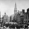
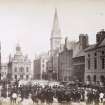
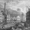
Alternative Name(s) City Square; Pillars; Town Hall
Canmore ID 183041
Site Number NO43SW 232
NGR NO 4033 3023
NGR Description c. NO 4033 3023
Datum OSGB36 - NGR
Permalink http://canmore.org.uk/site/183041


- Council Dundee, City Of
- Parish Dundee (Dundee, City Of)
- Former Region Tayside
- Former District City Of Dundee
- Former County Angus
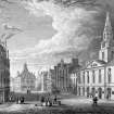
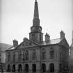
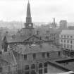
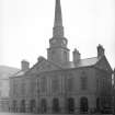
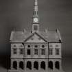
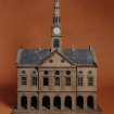
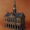
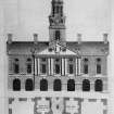
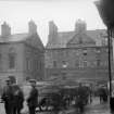
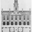
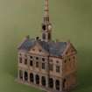
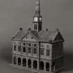
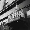
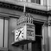
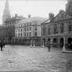
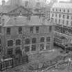
Built between 1732 and 1734, Dundee Town House was built in Classical style by William Adam. The building featured a steeple over 40m high, which rose from the centre of the roof. At ground level, arcades enclosing shops gave it the local name 'The Pillars'. The council and guildry chambers were on the first floor with the jail above. The town house was repaired after a fire in 1771, extended to the rear in 1872, and demolished in 1932.
Information from RCAHMS 1996
NMRS REFERENCE:
Dundee, High Street, Town House.
ARCHITECT: William Adam 1732-5
David McKenzie 1871 (extension)
Demolished 1932.
NMRS/Simpson & Brown photographs.
Box 6 album no 91
1988 model for William Adam exhibition in SNPG.
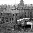
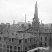
Photographic Survey (1900 - 1932)
Photographic survey by the Ministry of Works prior to demolition.
Watching Brief (20 January 1995 - 27 January 1995)
NO 403 302 In January 1995 the Trust undertook a watching brief to monitor groundworks for environmental improvements on the N and S sides of High Street, Dundee. These areas had been stripped to a depth of c0.40m in preparation for new surfaces and several tree pits, up to 2m in depth, had been excavated.
Archaeological deposits and features were recorded in groundworks for resurfacing and excavations for tree planters. Unstratified animal bone, mainly from groundworks for services in front of the city square, was also recovered. Of particular interest was the discovery of the foundation remains of the 1731 Adam's townhouse.
Sponsor: Scottish Enterprise Tayside
Report Summarised below.
During the period 20th-27th January 1995 the Trust undertook an archaeological watching brief to monitor groundworks for environmental improvements on the north and south sides of High Street, Dundee. These areas had been stripped to a depth of about 0.40m in preparation for new surfaces.
Previous observations on the environmental improvements in South High Street and Commercial Street/Murraygate had revealed medieval pottery, bone, former road surfaces and building remains…
Archaeological information in the form of deposits and features were recorded in groundworks for resurfacing and excavations for tree planters. Unstratified animal bone, mainly from groundworks for services in front of the city square were also recovered.
Of particular interest was the discovery of foundation remains for the 1731 Adam's townhouse.
The environmental works along the High Street have involved a substantial amount of below ground work which has both revealed and disturbed important archaeological levels below the High Street and the pavement. The watching brief has proved very helpful in verifying the degree and extent of archaeological survival.
It was ascertained that survival appears best on the south side of the High Street, and although severely truncated by services it was still possible to find remains of archaeological deposits; this seems particularly true further out into the High Street, where deposits may have been protected by the High Street surface, the deposits recorded in areas B and D tentatively indicate that the High Street was at one time much narrower than it is today. In area C, the foundations for the famous pillars were revealed showing that major building remains can exist in good order at a relatively shallow level below present surfaces. On the north side of the High Street at Boot's Corner in areas G, K and F, remains show that late 19th century development has swept away any medieval deposits and that this development in turn was cleared for the Overgate Centre.
Information from SUAT, 1995

