
Hoy, Quoy-i-dale


Farmstead (Period Unassigned)
Site Name Hoy, Quoy-i-dale
Classification Farmstead (Period Unassigned)
Canmore ID 182582
Site Number HY20SW 32
NGR HY 2400 0344
Datum OSGB36 - NGR
Permalink http://canmore.org.uk/site/182582


- Council Orkney Islands
- Parish Hoy And Graemsay
- Former Region Orkney Islands Area
- Former District Orkney
- Former County Orkney
HY20SW 32 2400 0344
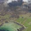
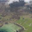
A farmstead, comprising three roofed buildings, one unroofed building and one enclosure is depicted on the 1st edition of the OS 6-inch map (Orkney and Shetland (Orkney) 1882, sheet cix). One roofed building and one enclosure are shown on the current edition of the OS 1:10000 map (1973).
Information from RCAHMS (AKK) 20 December 2000.

