
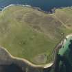
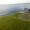
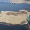
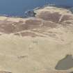
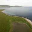
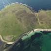
Eynhallow


Farmstead (Period Unassigned)
Site Name Eynhallow
Classification Farmstead (Period Unassigned)
Canmore ID 182339
Site Number HY32NE 67
NGR HY 3615 2865
Datum OSGB36 - NGR
Permalink http://canmore.org.uk/site/182339


- Council Orkney Islands
- Parish Rousay And Egilsay
- Former Region Orkney Islands Area
- Former District Orkney
- Former County Orkney
HY32NE 67 3615 2865
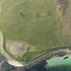
A farmstead comprising one unroofed long building, one roofed building and a complex series of enclosures is depicted on the 1st edition of the OS 6-inch map (Orkney and Shetland (Orkney) 1882, sheet lxxxix). One roofed building and three enclosures are shown on the current edition of the OS 1:10000 map (1977).
Information from RCAHMS (SAH) 18 December 2000
Ground Survey (25 April 2007 - 29 April 2007)
HY 36041 29076 A desk-based assessment and walkover survey of the island of Eynhallow was undertaken in April 2007. A total of 65 sites were recorded, ranging from post-medieval buildings to prehistoric structures. Of particular interest was the identification of a previously unrecorded burnt mound in the N of the island, several possible prehistoric burial mounds and a well preserved sequence of field dykes. Although further work is required to understand these boundaries, initial assessment suggests there is clear phasing and chronological depth to these features which may include potential prehistoric land divisions.
Report to be deposited with the Orkney SMR and RCAHMS.
Funder: Hunter Archaeological Trust, Viking Society for Northern Research, Orkney Archaeological Trust, Orkney College Geophysics Unit.
Field Visit (12 August 2015)
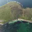
What may be the remains of a farmstead are situated amongst a group of structures, near the rocky foreshore known as Sheep Skerry at the S tip of Eynhallow. The latter include an abandoned but roofed building and ten contiguous, irregularly-shaped drystone enclosures, each of which is shown on the 1st edition of the OS 25 inch map (Orkney Sheet LXXIX.7, 1882).
Visited by RCAHMS (GFG) 12 August 2015
Moore and Thomas 2008, Site 26

