
Rousay, Dale


Farmstead (Post Medieval), Head Dyke (Post Medieval), Kiln Barn (Post Medieval), Structure(S) (Period Unassigned)
Site Name Rousay, Dale
Classification Farmstead (Post Medieval), Head Dyke (Post Medieval), Kiln Barn (Post Medieval), Structure(S) (Period Unassigned)
Canmore ID 182038
Site Number HY33SE 58
NGR HY 3759 3200
Datum OSGB36 - NGR
Permalink http://canmore.org.uk/site/182038


- Council Orkney Islands
- Parish Rousay And Egilsay
- Former Region Orkney Islands Area
- Former District Orkney
- Former County Orkney
HY33SE 58 3759 3200
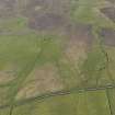
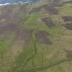
A farmstead comprising two unroofed buildings and one enclosure, two unroofed structures lying approximately 180m to the NNW and a head-dyke are depicted on the 1st edition of the OS 6-inch map (Orkney and Shetland (Orkney) 1882, sheet lxxxiv). One unroofed building is shown on the current edition of the OS 1:10000 map (1977).
Information from RCAHMS (SAH) 11 December 2000
Field Visit (15 May 2015)
This farmstead comprises two ranges set side-by-side at the SE end of an enclosure; both are orientated NW and SE, and they lie up-and-down the slope. The W range measures about 10m in length over ruinous stone walls and contains two compartments of different dates, the lower and NW of which is a kiln-barn. The E range measures 15m in length and originally contained three compartments later reduced to two, the NW one a byre with a drain running out to a midden.
The subrectangular enclosure to the N of the buildings measures about 33m from NNW to SSE by 19m transversely within a wall reduced to a grass-grown bank. There are strong indications that these buildings overlie and incorporate elements of an earlier range set across the slope, probably originally forming the SSE end of the enclosure. An enclosed field that lies across the burn to the NE probably belonged to the farmstead. Within the field are the footings of a small rectangular enclosure (HY33SE 152).
Thompson (1981, 46) notes that Dale or Deall was a farm of 4 acres (1.6ha) arable that was cleared in 1845. The two buildings are depicted unroofed on the 1st edition of the OS 25-inch map (Orkney 1882, Sheet LXXXIV.16) and a contemporary account states that the name applied to the ‘ruins of a dwelling’ (Name Book 16, 25).
Visited by RCAHMS (GFG, KN) 15 May 2015.

