
Rousay, Breck


Farmstead (Post Medieval)
Site Name Rousay, Breck
Classification Farmstead (Post Medieval)
Canmore ID 182034
Site Number HY33SE 54
NGR HY 3758 3264
Datum OSGB36 - NGR
Permalink http://canmore.org.uk/site/182034


- Council Orkney Islands
- Parish Rousay And Egilsay
- Former Region Orkney Islands Area
- Former District Orkney
- Former County Orkney
HY33SE 54 3758 3264
A farmstead comprising one unroofed building and two conjoined enclosures, a second unroofed building lying approximately 180m to the WNW, and a head-dyke are depicted on the 1st edition of the OS 6-inch map (Orkney and Shetland (Orkney) 1882, sheet lxxxiv). The head-dyke is conjoined to that of the farmstead of Breek (HY33SE 53).
One unroofed building, one enclosure and the fragmentary remains of the head-dyke are shown on the current edition of the OS 1:10000 map (1977).
Information from RCAHMS (SAH) 11 December 2000
Field Visit (20 August 2014)
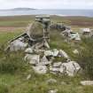
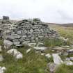
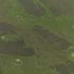
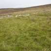
The ruinous farmstead of Breck is one of a number of smallholdings that are strung out along the grass- and heather-grown SW flank of the ridge known as the Brae of Moan. It sits within a field of about 9 acres, lying adjacent to the contemporary field of the farmstead of Breek (HY33SE 53) on the N, but separated by unimproved moorland from the fields of Cairn to the S (HY33SE 55) and Tafts to the W (HY33SW 44). The broader landscape, including the field-system associated with the Quendal township, is described elsewhere (see HY33SE 163).
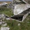
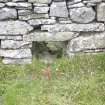
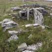
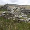
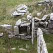
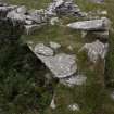
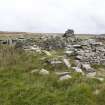
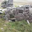
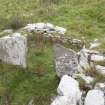
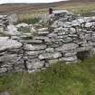
The farmstead comprises two parallel rectangular ranges separated by a narrow passage, which stand on the S side of a stone-walled enclosure. The ranges are orientated against the slope, with their upper, eastern, ends constructed on ground that has been levelled into the slope. The principal (N) building is a range that has developed from a two-roomed dwelling measuring 8.6m from E to W by 3.5m transversely within drystone walls 0.7m in thickness and up to 1.3m in height. There is a doorway at the W end of the S side and an internal partition wall separates the interior into two unequal parts, the smaller being at the E end. The larger room contains a quern ledder in its NW corner and bed-neuk that projects out N from its NE corner. The entrance to this bed-neuk is flanked by two large edge-set slabs and its E end-wall contains a small niche. Three more niches, two of them set one above the other, are visible in the S wall. Two further edge-set slabs which may be the remains of some form of internal porch have been set up inside the entrance. One slab projects from the inner face of the W wall and other projects from the inner face of the S a little to the E of the doorway. This slab also marks the southern end of a step in the floor level that runs all the way across to the inner face of the N wall. This step may mark a former division of the room or it may simply represent the levelling of floors within a building built on a slope. Both the small room to the E of the larger and a similarly sized room that represents an addition to the western end of the building are entered via doorways from the main room. As they survive today, both rooms are featureless.
The S range contains a kiln-barn at its E end, a byre and, at its W end, what was probably a small store room. The barn measures 4m from E to W by 2.5m transversely within a drystone wall 0.6m in thickness. The kiln, which is set into its NE corner, stands 1.9m high and contains a bowl measuring 1.2m in diameter. There is a small store next to it on the S. The entrance to the barn is in its N wall (almost opposite the entrance to the dwelling) and in its S wall (opposing the barn entrance) there is a winnowing hole. The byre, which represents an addition to the original structure, measures only 2.5m in length from E to W; it has an entrance in its N side and a drain exits under its W end. The small store attached to the W end of the byre has an entrance in its N side.
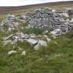
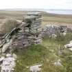
The main (W) part of the stone-walled enclosure to the N of the buildings measures about 28m from E to W by 18m transversely and contains the faint traces of what may be the remains of two other rectangular buildings. This part of the enclosure is separated from the smaller, SE, part by a bank and ditch which extends S beyond the enclosure and which may have been a drain.
The farmstead and enclosure stand within a larger field of about 9 acres. The discrepancy between this and a recorded figure of 11 acres could be explained by the inclusion of the arable around Cairn, with which Breck may have been combined (Thomson 1981, 46). Breck, home to a family of five in 1841, was cleared of its tenants in 1845 (ibid). The unroofed farmstead and enclosure is depicted on the 1st edition of the OS 25-inch map (Orkney 1882, Sheet LXXXIV.12) and a contemporary account states that the name applied to ‘the ruin of a dwelling’ (Name Book Vol.16, p.27).
Visited by RCAHMS (GFG, AM) 20 August 2014.
Measured Survey (20 August 2014)
RCAHMS surveyed the farmstead at Breck, Rousay on 20 August 2014 with plane-table and self-reducing alidade at a scale of 1:250. The resultant plan was redrawn in vector graphics at a scale of 1:500.
Excavation (11 May 2015 - 16 July 2015)
HY 3758 3264 (Breck), HY 37384 30093 (Skaill) and HY 37289 30396 (Brough) Archaeological investigations into the Rousay clearances took place at two sites, c2.5 km apart, in the W of Rousay, 11 May – 16 July 2015. Excavation was undertaken at Breck Farmstead in Quandale in conjunction with measured and landscape survey by RCAHMS of the neighbouring farmsteads. In addition, a building recording survey was undertaken and a test pit excavated at Skaill Farm, Westness. Geophysical survey (magnetometry) was also undertaken at Skaill and nearby Brough Farm. The project was in partnership with the ongoing excavations at Swandro multi-period settlement and tombs (University of Bradford), and investigation of the multi-period landscapes of the island.
At Breck (11–22 May 2015), eight small keyhole trenches were excavated within the farm buildings and four test pits around the nearby enclosure. Breck consisted of two building ranges separated by a close (but and ben with additional room, and corn kiln, barn and byre). The earth floor in the but end had been replaced and the remains of a leather shoe was found buried in the upper floor layer. In a similar manner, the original central hearth slab in the but end had been overlain by another slab which also had a rough back wall. A ‘Z’ motif had been carved into the SW end of the lower hearth slab and may have been a good luck charm. The hearth appears to have been replaced along with the floor. Paving slabs and stone roof slabs were found in the close. The presence of window glass suggests that the stone roof had small skylights. The corn drying kiln had a flue into the barn, both had been swept clean. A dump of pottery was found in the neuk bed and byre drain. Indications are that the farm was built in the late 18th to early 19th century as an outset into the hill land beyond the hill dyke. A team from RCAHMS led by George Geddes prepared notes on 68 sites within the Quandale area, and produced measured surveys of seven farmsteads (North House HY33SE 49, Hestival HY33SE 51, Breek HY33SE 53, Cairn HY33SE 55, Knapknowes HY33SE 60).
At Skaill Farm, measured building survey was undertaken at the two ranges and corn kiln. Geophysical survey (magnetometer) was undertaken in four blocks around the farmstead and also a single block at Brough Farm. The results from Skaill indicated the presence of earlier boundaries on a different alignment to the present post-medieval boundaries, which may relate to an earlier farm.
A small test pit was excavated in the garden area adjacent to the main farmhouse to investigate potential post-medieval midden for animal bone assemblages (8–9 and 14–15 July 2015). Midden enhanced topsoil (containing pottery, animal bone, glass and a 1743 half penny) sealed a stony demolition layer (containing fish bones and a sherd of steatite) which in turn sealed a stone wall. The wall was on a slightly different alignment to the main farm building and is likely to relate to an earlier structure and the other geophysical anomalies. The steatite suggests that the earlier farm could date to the
Viking period.
Archive: Archaeology Institute, UHI
Funder: Orkney Islands Council, Orkney Archaeology Society and Archaeology Institute, UHI
Daniel Lee, Keir Strickland, Jane Downes, Ingrid Mainland and George Geddes – Archaeology Institute, UHI and HES
(Source: DES, Volume 16)

