
Rousay, Breek


Farmstead (Post Medieval), Kiln Barn (Post Medieval), Rotary Quern (Post Medieval)
Site Name Rousay, Breek
Classification Farmstead (Post Medieval), Kiln Barn (Post Medieval), Rotary Quern (Post Medieval)
Canmore ID 182033
Site Number HY33SE 53
NGR HY 3751 3287
Datum OSGB36 - NGR
Permalink http://canmore.org.uk/site/182033


- Council Orkney Islands
- Parish Rousay And Egilsay
- Former Region Orkney Islands Area
- Former District Orkney
- Former County Orkney
HY33SE 53 3751 3287
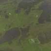
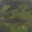
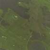
A farmstead comprising three unroofed buildings, two enclosures and four unroofed structures lying approximately 100m to the SSW, 170m to the SSW, 60m to the SSE and 90m to the NNE respectively, and a head-dyke are depicted on the 1st edition of the OS 6-inch map (Orkney and Shetland (Orkney) 1882, sheet lxxxiv). The head-dyke is conjoined to those of the farmsteads of Breck (HY33SE 54), Hestivall (HY33SE 51) and Lower Breck (HY33SE 52).
Two unroofed buildings and the fragmentary remains of the head-dyke are shown on the current edition of the OS 1:10000 map (1977).
Information from RCAHMS (SAH) 11 December 2000
Field Visit (11 May 2015 - 12 May 2015)
This farmstead comprises two parallel ranges, orientated NE and SW, and a third building immediately south, all set within a stone-walled yard that overlies earlier boundaries and cultivation terraces on the NE and E. The rectangular principal range lies up-and-down the slope and has developed from an original dwelling the remains of which measure at least 7.2m by 4.6m over walls up to 0.7m in thickness and standing up to 1.5m in height. There is a doorway at the SW end of the SE side and another, which is situated close to the SW end of the NW side, leads into a bed-neuk which is of secondary build. In the NW corner of the interior there is a shelf for a pair of rotary querns. An outshot at the SW end of the dwelling has a doorway in its SE side and there is an extension at the NE end was possibly built in two phases. This extension measures 4m in internal length but at only 2.6m in breadth, it is marginally narrower than the main building. The extension was accessed by way of a door in the NE end of the dwelling.
A narrow passageway separates the range containing the dwelling from another immediately to the SE which comprises a kiln-barn with what was probably a later byre attached to its SW end. The kiln-barn measures 7m by 3.6m transversely over walls up to 0.7m in thickness, and there is an entrance in the NW side opposite a winnowing hole in the SE side. The kiln and a small store adjacent to it on the SE are built into the rounded NE end of the building, and there are two vertical slit vents in the SW gable which is shared with the byre. A blocked doorway in the NW side and a blocked opposing winnowing hole in the SE side indicate that the barn has been lengthened – probably when the SW end of the range containing the byre was constructed. This part, which measures 3m by 2.2m internally has an entrance on the NW. The third building measures 5m from NW to SE by 3.8m transversely and there is a doorway in the NW end, where a fragment of rotary quern is can be seen amongst collapsed rubble.
Thomson (1981, 46) notes that the farmstead of Breek, which was associated with 11 acres (4.45ha) of arable, had three inhabitants in 1841 but was cleared in 1845. Three unroofed buildings are depicted here on the 1st edition of the OS 25-inch map (Orkney 1882, Sheet LXXXIV.2) and a contemporary reference stated that the name applied to ‘a ruinous building’ (Name Book 16, 12).
Visited by RCAHMS (GFG, AM) 11–12 May 2015
Measured Survey (11 May 2015 - 12 May 2015)
RCAHMS surveyed Breek farmstead with plane-table and alidade on 11 May 2015 at a scale of 1:200. The resultant plan was redrawn in vector graphics software.
Excavation (11 May 2015 - 16 July 2015)
HY 3758 3264 (Breck), HY 37384 30093 (Skaill) and HY 37289 30396 (Brough) Archaeological investigations into the Rousay clearances took place at two sites, c2.5 km apart, in the W of Rousay, 11 May – 16 July 2015. Excavation was undertaken at Breck Farmstead in Quandale in conjunction with measured and landscape survey by RCAHMS of the neighbouring farmsteads. In addition, a building recording survey was undertaken and a test pit excavated at Skaill Farm, Westness. Geophysical survey (magnetometry) was also undertaken at Skaill and nearby Brough Farm. The project was in partnership with the ongoing excavations at Swandro multi-period settlement and tombs (University of Bradford), and investigation of the multi-period landscapes of the island.
At Breck (11–22 May 2015), eight small keyhole trenches were excavated within the farm buildings and four test pits around the nearby enclosure. Breck consisted of two building ranges separated by a close (but and ben with additional room, and corn kiln, barn and byre). The earth floor in the but end had been replaced and the remains of a leather shoe was found buried in the upper floor layer. In a similar manner, the original central hearth slab in the but end had been overlain by another slab which also had a rough back wall. A ‘Z’ motif had been carved into the SW end of the lower hearth slab and may have been a good luck charm. The hearth appears to have been replaced along with the floor. Paving slabs and stone roof slabs were found in the close. The presence of window glass suggests that the stone roof had small skylights. The corn drying kiln had a flue into the barn, both had been swept clean. A dump of pottery was found in the neuk bed and byre drain. Indications are that the farm was built in the late 18th to early 19th century as an outset into the hill land beyond the hill dyke. A team from RCAHMS led by George Geddes prepared notes on 68 sites within the Quandale area, and produced measured surveys of seven farmsteads (North House HY33SE 49, Hestival HY33SE 51, Breek HY33SE 53, Cairn HY33SE 55, Knapknowes HY33SE 60).
At Skaill Farm, measured building survey was undertaken at the two ranges and corn kiln. Geophysical survey (magnetometer) was undertaken in four blocks around the farmstead and also a single block at Brough Farm. The results from Skaill indicated the presence of earlier boundaries on a different alignment to the present post-medieval boundaries, which may relate to an earlier farm.
A small test pit was excavated in the garden area adjacent to the main farmhouse to investigate potential post-medieval midden for animal bone assemblages (8–9 and 14–15 July 2015). Midden enhanced topsoil (containing pottery, animal bone, glass and a 1743 half penny) sealed a stony demolition layer (containing fish bones and a sherd of steatite) which in turn sealed a stone wall. The wall was on a slightly different alignment to the main farm building and is likely to relate to an earlier structure and the other geophysical anomalies. The steatite suggests that the earlier farm could date to the
Viking period.
Archive: Archaeology Institute, UHI
Funder: Orkney Islands Council, Orkney Archaeology Society and Archaeology Institute, UHI
Daniel Lee, Keir Strickland, Jane Downes, Ingrid Mainland and George Geddes – Archaeology Institute, UHI and HES
(Source: DES, Volume 16)

