
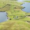
Booth Of Lunna


Fishing Bothy (18th Century)
Site Name Booth Of Lunna
Classification Fishing Bothy (18th Century)
Alternative Name(s) Lumnasting, Lunna, Fishing Booth, Including Drying Beach
Canmore ID 181752
Site Number HU46NE 20
NGR HU 48659 69052
Datum OSGB36 - NGR
Permalink http://canmore.org.uk/site/181752


- Council Shetland Islands
- Parish Nesting
- Former Region Shetland Islands Area
- Former District Shetland
- Former County Shetland
Single storey and attic, 3-bay symmetrical former trading booth with gabled wing centred to rear forming T-plan. Harl-pointed rubble walls. Rubble apex stacks to gables, stone copes and flanked by rubble and concrete skew copes. The ground floor of this booth is divided into three chambers, the centre chamber extending back to the gable of the rear wing. The thick walls contain fireplaces in the E and W gables at 1st floor.
The drying beach is partly man-made. Although currently (1996) a roofless ruin, this is one of the largest and best preserved of Shetland's fishing booths, and unusual in being T-plan in layout. (Historic Scotland)

