
Nenthorn, General


Church (Period Unassigned), Manse (Period Unassigned), Smithy (Period Unassigned), Village (Period Unassigned)
Site Name Nenthorn, General
Classification Church (Period Unassigned), Manse (Period Unassigned), Smithy (Period Unassigned), Village (Period Unassigned)
Canmore ID 181450
Site Number NT63NE 25
NGR NT 67981 37377
NGR Description Centred on NT 67981 37377
Datum OSGB36 - NGR
Permalink http://canmore.org.uk/site/181450


- Council Scottish Borders, The
- Parish Nenthorn
- Former Region Borders
- Former District Roxburgh
- Former County Berwickshire
NT63NE 25 Centred 67981 37377
See also: NT63NE 16 68026 37343 Church
NMRS REFERENCE
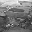
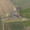
A village comprising one unroofed building annotated Ruin, which has only three walls marked, ten roofed buildings, which include a Smithy, a Church (NT63NE 16), a Free Church and a Free Church Manse, and ten enclosures is depicted on the 1st edition of the OS 6-inch map (Berwickshire 1862, sheet xxxi). Nine roofed buildings and seven enclosures are shown on the current edition of the OS 1:10000 map (1988).
Information from RCAHMS (SAH) 27 September 2000

