
Following the launch of trove.scot in February 2025 we are now planning the retiral of some of our webservices. Canmore will be switched off on 24th June 2025. Information about the closure can be found on the HES website: Retiral of HES web services | Historic Environment Scotland
Athelstaneford, General


Village (Period Unassigned)
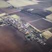
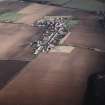
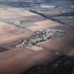
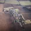
Site Name Athelstaneford, General
Classification Village (Period Unassigned)
Canmore ID 181421
Site Number NT57NW 116
NGR NT 5361 7732
NGR Description Centred on NT 5361 7732
Datum OSGB36 - NGR
Permalink http://canmore.org.uk/site/181421


- Council East Lothian
- Parish Athelstaneford
- Former Region Lothian
- Former District East Lothian
- Former County East Lothian
NT57NW 116 centred on 535 773
See also:
NT57NW 2 NT 5329 7735 Church; Burial Ground; Burial Enclosure
NT57NW 15 NT 5326 7737 Dovecot
NT57SW 11 NT 5348 7733 Market Cross
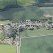
A village comprising three unroofed buildings, one of which is annotated Remains of Church (12th C.) (NT57NW 2) and the others are annotated Ruin, two partially roofed buildings, one of which is annotated Ruin, thirty-seven roofed buildings, which include a church (NT57NW 2), a manse, a school, a smithy, a brewery, a kiln and a dove cot (NT57NW 15), several unroofed structures lying within a grave yard and thirty-two enclosures is depicted on the 1st edition of the OS 6-inch map (Haddingtonshire 1854, sheet 5). Forty-seven roofed buildings and their associated enclosures are shown on the current edition of the OS 1:10000 map (1991).
Information from RCAHMS (SAH) 28 September 2000
NT 536 775 Trial trenching amounting to 370m² was carried out in July 2004 in advance of development for housing, as the site lay on the outskirts of the village in an area of archaeological potential. There were no finds of archaeological significance.
Archive to be deposited in the NMRS.
Sponsor: Robertson Homes.
M Kirby 2004
NT57NW 116 5361 7732
The location of the War Memorial (CSE 1920/127/1) cannot be established at time of entry (AC 23 April 2002).

