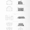
Accessibility

Font Size

100% 150% 200%

Background Colour

Default Contrast
Close Reset

Sandwick, Manse

Manse (19th Century)

Site Name Sandwick, Manse

Classification Manse (19th Century)

Canmore ID 180984

Site Number HU42SW 38

NGR HU 43005 24079

Datum OSGB36 - NGR

Permalink http://canmore.org.uk/site/180984

Ordnance Survey licence number AC0000807262. All rights reserved.
Canmore Disclaimer. © Bluesky International Limited 2025. Public Sector Viewing Terms

Toggle Aerial | View on large map

Digital Images

View from ESE.
View from ESE.View from NW.Engraving of map  inscr: ''Map of Scotland shewing The Highland Roads and Bridges made, the Harbours improved and Churches built in the Highlands, also the Glasgow and Lanarkshire Roads, all according to the Plans of Thomas Telford. Shewing also the Old Military Roads still maintained in use.''Oblique aerial view.Oblique aerial view.Engraving of elevation and plan inscr: ''Highland Churches and Manses.'' Includes plans, and elevations of church, one storey manse, and two storey manse.

Administrative Areas

  • Council Shetland Islands
  • Parish Dunrossness
  • Former Region Shetland Islands Area
  • Former District Shetland
  • Former County Shetland

Archaeology Notes

HU42SW 38.00 HU 43005 24079

Manse [NAT]

OS 1:10,000 map, 1973.

HU42SW 38.01 HU 43036 24068 Walled Garden

HU42SW 38.02 HU 43058 24058 Summerhouse

HU42SW 38.03 HU 42291 24096 North Outbuilding

HU42SW 38.04 HU 42985 24078 South Outbuilding

For associated church (HU 4328 2378), see HU42SW 37.

See also HU31SE 8020.

References

MyCanmore Image Contributions


Contribute an Image

MyCanmore Text Contributions