
Brough Road, Buckquoy


Building (Period Unassigned)(Possible)
Site Name Brough Road, Buckquoy
Classification Building (Period Unassigned)(Possible)
Canmore ID 1805
Site Number HY22NW 17
NGR HY 2438 2820
Datum OSGB36 - NGR
Permalink http://canmore.org.uk/site/1805


- Council Orkney Islands
- Parish Birsay And Harray
- Former Region Orkney Islands Area
- Former District Orkney
- Former County Orkney
HY22NW 17 2438 2820.
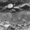
A line of stones, possibly the wall of a building, which may be associated with the settlement to the NW (HY22NW 14) or may be a separate site. The stones are apparently carefully set and run parallel to the road, with, possibly, the end of a second wall adjacent and running at right angles. Exposed by erosion of sand-cliff.
C D Morris 1983, 1978, 1977 and 1979.

