
Pricing Change
New pricing for orders of material from this site will come into place shortly. Charges for supply of digital images, digitisation on demand, prints and licensing will be altered.
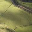
Old Buckholm


Farmstead (Period Unassigned)
Site Name Old Buckholm
Classification Farmstead (Period Unassigned)
Canmore ID 180378
Site Number NT43NE 9.01
NGR NT 483 379
Datum OSGB36 - NGR
Permalink http://canmore.org.uk/site/180378

- Council Scottish Borders, The
- Parish Melrose
- Former Region Borders
- Former District Ettrick And Lauderdale
- Former County Roxburghshire
NT43NE 9.01 483 379
A farmstead comprising one unroofed building, three partially roofed buildings, two of which are long buildings, three roofed buildings, one of which is annotated Buckholm Tower (NT43NE 9), and four enclosures is depicted on the 1st edition of the OS 6-inch map (Roxburghshire 1854-62-3, sheet iii). Two partially roofed buildings, two roofed buildings and three enclosures, one of which is incomplete, are shown on the current edition of the OS 1:10000 map (1983).
Information from RCAHMS (SAH) 13 July 2000

