
Red Craig


Building (Period Unassigned), Structure (Period Unassigned)
Site Name Red Craig
Classification Building (Period Unassigned), Structure (Period Unassigned)
Canmore ID 1803
Site Number HY22NW 15
NGR HY 2448 2816
Datum OSGB36 - NGR
Permalink http://canmore.org.uk/site/1803


First 100 images shown. See the Collections panel (below) for a link to all digital images.
- Council Orkney Islands
- Parish Birsay And Harray
- Former Region Orkney Islands Area
- Former District Orkney
- Former County Orkney
HY22NW 15.00 2448 2816
HY22NW 15.01 HY 2466 2807 Stone Gaming Board
HY22NW 15.02 HY 2448 2816 Glass Bead
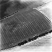
Visible walling noted in 1976 in the cliff section at Red Craig, lying below turf and on the natural clay. Resistivity survey preceded excavation which, in 1978, proved this to be the S walling of a figure-of-eight building, probably pre-Norse, containing a vast amount of stone which may indicate that the building was corbelled. The W room, which had a S facing door, contained little occupational material, but the E room possessed two central fire pits and a later horse-shoe shaped hearth. There was limited artefactual material (Area 3). An area to the E was excavated as a separate area (Area 4).
C D Morris 1978a; 1979; 1979h; 1979i; 1983; 1989.
Projecting stones in cliff section which proved on excavation in 1979 (Area 5) to be the possible remains of an extensively eroded structure lying at right-angles to the building in Area 3 (see above). Small finds are in Tankerness House Museum, Kirkwall. Formerly HY22NW 58.
C D Morris 1978a, 1979h, 1979i, 1980a, 1989.
Carbonised seed from various points in Area 3 gave radiocarbon dates of 1060 +/- 60bp (GU-1230); 1250 +/- 110bp (GU-1958) and 1240 +/- 110bp (GU-1959). Small finds are in Tankerness House Museum, Kirkwall; biological material in the Royal Museum of Scotland (RMS), Edinburgh.
Excavation work took place in 1978 (Areas 3 & 4) after resistivity surveys in 1977 & 1978 detected possible structural remains. Phase A contained the only significant archaeological features which are associated with the building in Area 3. Phase C contained the modern road rubble which was detected by survey (Area 4). The structure in the W part of Area 3 was re-excavated in 1979 as Area 5 (see above).
C D Morris 1989
Information from RCAHMS (FO) 16 June 1997

