|
Photographs and Off-line Digital Images |
C 32132 |
Survey of Private Collections |
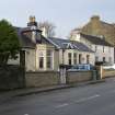
Bute, Rothesay, Ardbeg Road, Currie's Grocery Shop.
General view of shop front. |
|
Item Level |
|
 |
On-line Digital Images |
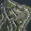
DP 067187 |
RCAHMS Aerial Photography Digital |
General oblique aerial view, taken from the SSE. |
6/10/2009 |
Item Level |
|
 |
On-line Digital Images |
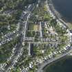
DP 067188 |
RCAHMS Aerial Photography Digital |
General oblique aerial view, taken from the SE. |
6/10/2009 |
Item Level |
|
 |
On-line Digital Images |
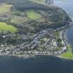
DP 067189 |
RCAHMS Aerial Photography Digital |
General oblique aerial view, taken from the E. |
6/10/2009 |
Item Level |
|
 |
On-line Digital Images |
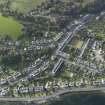
DP 067193 |
RCAHMS Aerial Photography Digital |
General oblique aerial view looking towards Ardbeg, taken from the ESE. |
6/10/2009 |
Item Level |
|
 |
On-line Digital Images |
DP 098699 |
Records of the Royal Commission on the Ancient and Historical Monuments of Scotland (RCAHMS), Edinbu |
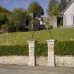
View of lantern above gates in boundary wall to 3 Ardbeg Road, Ardbeg, Rothesay, Bute, from NE |
27/4/2011 |
Item Level |
|
|
Print Room |
PA 9/19V |
General Collection. Photograph Albums. |
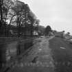
General view of Ardbeg.
Titled 'Ardbeg and the Cowal Hills'.
PHOTOGRAPH ALBUM No.9: MISS FRANK'S PRINCE CHARLIE ALBUM. |
c. 1850 |
Item Level |
|
 |
On-line Digital Images |
SC 1801782 |
Scottish Development Department |
Port Bannatyne, Ardbeg Road, North Bute parish, Argyll & Bute |
5/1983 |
Item Level |
|
 |
On-line Digital Images |
DP 319699 |
Records of the Royal Commission on the Ancient and Historical Monuments of Scotland (RCAHMS), Edinbu |
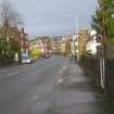
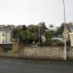
General view from south-east looking along Ardbeg Road towards High Road, Ardbeg, Rothesay, Bute. |
4/2/2010 |
Item Level |
|
 |
On-line Digital Images |
DP 319700 |
Records of the Royal Commission on the Ancient and Historical Monuments of Scotland (RCAHMS), Edinbu |
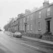
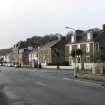
General view from north-east showing Nos 65, 69, 71 and 73 Ardbeg Road, Ardbeg, Rothesay, Bute. |
4/2/2010 |
Item Level |
|
 |
On-line Digital Images |
DP 319703 |
Records of the Royal Commission on the Ancient and Historical Monuments of Scotland (RCAHMS), Edinbu |
General view from east showing Ardbeg area, Rothesay, Bute. |
4/2/2010 |
Item Level |
|
 |
On-line Digital Images |
DP 319753 |
Records of the Royal Commission on the Ancient and Historical Monuments of Scotland (RCAHMS), Edinbu |
General view from north-east showing Ardbeg Road, Ardbeg, Rothesay, Bute. |
4/2/2010 |
Item Level |
|
 |
On-line Digital Images |
SC 1978321 |
Scottish Development Department |
1-13 Ardbeg Road, Rothesay, Isle of Bute |
|
Item Level |
|


