
Pricing Change
New pricing for orders of material from this site will come into place shortly. Charges for supply of digital images, digitisation on demand, prints and licensing will be altered.
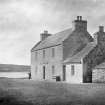
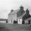
Hoy, North Ness, Ship Inn


Building (19th Century), Inn (20th Century), Post Office (20th Century)
Site Name Hoy, North Ness, Ship Inn
Classification Building (19th Century), Inn (20th Century), Post Office (20th Century)
Alternative Name(s) Longhope; Melsetter Post Office And Old Ship Inn
Canmore ID 179939
Site Number ND39SW 94
NGR ND 30552 91473
Datum OSGB36 - NGR
Permalink http://canmore.org.uk/site/179939


- Council Orkney Islands
- Parish Walls And Flotta
- Former Region Orkney Islands Area
- Former District Orkney
- Former County Orkney
ND39SW 94 30552 91473
The Ship Inn, depicted on the 1st dition of the OS 6-inch map, (Shetland and Orkney, sheet cxxiii, 1882) and noted in the Ordnance Survey Name Book (ONB 1880) as 'applied to an Inn in North Ness, two stories (sic) high the most southerly house in the district of North Ness. The property of I G Moodie Riddle Esq. Melsetter, Hoy'.
Information from RCAHMS (DE), February 2001.

