|
Manuscripts |
MS 500/19/12 |
|
3 sheets - map extracts.
2 sheets - rubbings of makers name plate
1 sheet - plans and detail of capstan
1 sheet - elevation of lighthouse
1 sheet - view looking N, plan of N pier, details
4 coloured postcards
1 sheet - photograph listing
6 b/w photographs, B/6066-71
2 colour photographs, G/91949-51/PO |
c. 1983 |
Item Level |
|
|
Manuscripts |
B 6066 |
|
General view along N wall of harbour. |
1/6/1983 |
Item Level |
|
|
Manuscripts |
B 6067 |
|
Detail of capstan on N wall of harbour. |
1/6/1983 |
Item Level |
|
|
Manuscripts |
B 6068 |
|
Detail of top of capstan on N wall of harbour. |
1/6/1983 |
Item Level |
|
|
Manuscripts |
B 6069 |
|
View from W. |
1/6/1983 |
Item Level |
|
|
Manuscripts |
B 6070 |
|
Detail of top. |
1/6/1983 |
Item Level |
|
|
Manuscripts |
B 6071 |
|
View from E. |
1/6/1983 |
Item Level |
|
|
Manuscripts |
G 91949 PO |
|
View from SE. |
1/6/1983 |
Item Level |
|
|
Manuscripts |
G 91950 PO |
|
View from E. |
1/6/1983 |
Item Level |
|
 |
On-line Digital Images |
DP 019350 |
RCAHMS Aerial Photography Digital |
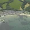
General oblique aerial view of the village centred on the harbour and the railway viaduct, taken from the NNE. |
7/7/2006 |
Item Level |
|
 |
On-line Digital Images |
SC 2373653 |
Records of the Ordnance Survey, Southampton, Hampshire, England |
Cullen Harbour, Harbour Light, NJ56NW 27.1, Ordnance Survey index card, Recto |
c. 1958 |
Item Level |
|


