
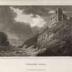
Findlater Castle


Castle (Medieval)
Site Name Findlater Castle
Classification Castle (Medieval)
Alternative Name(s) Barnyards Of Findlater
Canmore ID 17948
Site Number NJ56NW 15
NGR NJ 5418 6720
Datum OSGB36 - NGR
Permalink http://canmore.org.uk/site/17948


- Council Aberdeenshire
- Parish Fordyce
- Former Region Grampian
- Former District Banff And Buchan
- Former County Banffshire
NJ56NW 15 5418 6720
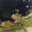
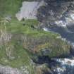
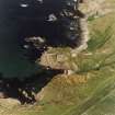
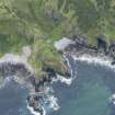
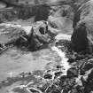
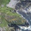
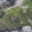
(NJ 5418 6720) Findlater Castle (NR) (In Ruins)
Fosse & Drawbridge (NR)
(Remains of)
Fosse (NR)
OS 6" map, (1938)
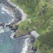
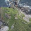
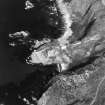
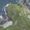
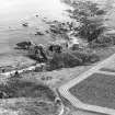
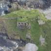
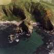
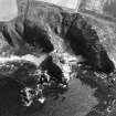
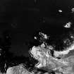
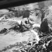
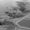
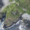
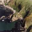
Findlater Castle - This once extensive fortress stood on a lofty detached rock, entirely surrounded by the sea, except where a narrow isthmus joins it to the mainland...
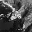
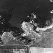
On the mainland the approach to the castle is defended by an intrenched area, having a ditch and rampart, 240ft by 140ft. The isthmus forming the access is cut across by two ditches, which no doubt were provided with drawbridges. Beyond this the ruins of the castle indicate several towers which command the approach. The area of the rock is about 180 feet by 80 feet and has been surrounded by buildings of which only the vaulted basement on the west side now remains. This part of the structure has been built up from a lower part of the rock to the level of the courtyard, and beneath this vault there is a still deeper chamber, partly hewn out of the rock. The castle...belonged from the time of David II to the St Clairs, afterwards to the Ogilvies, Earl of Findlater, and is now the property of the Earl of Seafield.
D MacGibbon and T Ross 1887-92; W D Simpson 1931.
The remains of this castle are generally as described by the foregoing authorities. The apporaches to it, on the mainland are defended by a rectangular bailey, consisting of a ditch with upcast bank on its inner side. The ditch is c.8.0m wide by c1.2m deep and the bank is 3.5m wide by 1.0m high. From here to the castle the approaches have been eroded away. The buildings on the west side of the castle area are in a very ruinous and dangerous condition, the walls still standing to an average height of c.20m from within. On the east side of the area only the outline of the stables and chapel can be traced.
Revised at 1/2500.
Visited by OS (WDJ), 19 September 1961.
Findlater Castle is as described above.
Visited by OS (NKB), 14 August 1967.
Information from Scots Magazine May 1981.
(Undated) information in NMRS.
Air photographs: AAS/94/06/G15/15-17.
NMRS, MS/712/21.
Classified as Site of Regional Significance: air photographic imagery and bibliography listed.
NMRS, MS/712/35.
Findlater, remains of a castle. Air photographs: AAS/00/14/G35/7-11 and AAS/00/14/CT.
NMRS, MS/712/100.
Findlater Castle.
NMRS NOTES
NB The designs by Robert Adam insc. 'Findlater Castle' are more likely to be for Cullen House. Marcus Binney 1985 says that they certainly are. See Cullen House slips/Canmore page.
EXTERNAL REFERENCE
University of Edinburgh Library.
Arnett, Terrence C : The Long Term Managament of an Eighteenth Century Banffshire Estate. PhD (1985).
Field Visit (September 2022)
NJ 54180 67200 Visited during fieldwork by SCAPE. No changes to description.
Information from S. Boyd and J. Hambly - Scottish Coastal Archaeology and the Problem of Erosion (SCAPE).

