Accessibility

Font Size

100% 150% 200%

Background Colour

Default Contrast
Close Reset

Newbattle Abbey Hostel, Military Camp

Military Camp (20th Century)

Site Name Newbattle Abbey Hostel, Military Camp

Classification Military Camp (20th Century)

Alternative Name(s) Newbattle Road

Canmore ID 178743

Site Number NT36NW 202

NGR NT 3335 6628

NGR Description NT c. 3335 6628

Datum OSGB36 - NGR

Permalink http://canmore.org.uk/site/178743

Ordnance Survey licence number AC0000807262. All rights reserved.
Canmore Disclaimer. © Bluesky International Limited 2025. Public Sector Viewing Terms

Toggle Aerial | View on large map

Digital Images

Scanned image of oblique aerial view of Newbattle Abbey, garden, sundials and military camp, taken from the N.
Scanned image of oblique aerial view of Newbattle Abbey, garden, sundials and military camp, taken from the N.Scanned image of oblique aerial view of Newbattle Abbey, garden, sundials and military camp, taken from the S.Oblique aerial view of Newbattle Abbey, garden, sundials and military camp, taken from the N.Oblique aerial view of Newbattle Abbey Hostel, taken from the NE.Oblique aerial view of Newbattle Abbey, garden, sundials and military camp, taken from the NNW.Oblique aerial view of Newbattle Abbey, garden, sundials and military camp, taken from the SE.Oblique aerial view centred on huts of military camp and Newbattle Abbey House, taken from the SW.Oblique aerial view of Newbattle Abbey, garden, sundials and military camp, taken from the WSW.Scanned image of oblique aerial view of Newbattle Abbey, garden, sundials and military camp, taken from the NNW.Oblique aerial view of Newbattle Abbey, garden, sundials and military camp, taken from the NE.Oblique aerial view of Newbattle Abbey Hostel, taken from the ESE.Oblique aerial view of Newbattle Abbey Hostel, taken from the WSW.Oblique aerial view centred on huts of military camp and Newbattle Abbey House, taken from the WNW.Oblique aerial view centred on huts of military camp and Newbattle Abbey House taken from the WSW.Oblique aerial view centred on huts of military camp and Newbattle Abbey House, taken from the SE.Oblique aerial view of Newbattle Abbey, garden, sundials and military camp, taken from the SW.Oblique aerial view of Newbattle Abbey, garden, sundials and military camp, taken from the NNE.Oblique aerial view of Newbattle Abbey, garden, sundials and military camp, taken from the S.Oblique aerial view of Newbattle Abbey Hostel, taken from the NW.

Administrative Areas

  • Council Midlothian
  • Parish Newbattle
  • Former Region Lothian
  • Former District Midlothian
  • Former County Midlothian

Architecture Notes

NT36NW 202 NT c. 3335 6628

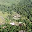
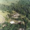
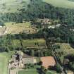
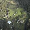
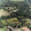
The full extent of the original military camp, which was constructed in the grounds of Newbattle Abbey House (NT36NW 14.00) is visible on vertical air photographs (106G/Scot/UK 11, 5117-5118, flown 15 April 1946). It extended from a point immediately SW of the Maiden Bridge (NT36NW) to an area now occupied by the small housing estate on Kirk Bank, N of Barondale House (NT 3303 6565). The hutted camp occupied approximately 19 hectares of parkland within the Newbattle Estate.

Visible on the air photographs are about 84 huts to the NE of the B703 Newbattle Road with a further 56 to the SW, immediately N of Barondale House. Many of the huts visible on the [hotographs have camouflaged roofs. Of the wartime huts, about 23 are still extant and used as part of the Newbattle Hostel, in an area to the N of Newbattle Abbey House.

The sewage filtration plant was at c.NT 3358 6633 and also visible on the photographs is a long practice trench (c.NT 3341 6611 to c.NT 3356 6624) with further short practice trenches at c.NT 3351 6659 and c.NT3363 6654. No trace of any of the trenches has been noted from more recent aerial photography (RCAHMS 1997), and the hutted camp to the SW has now been built over by a new housing estate.

Infdormation from RCAHMS (DE), March 2007

References

MyCanmore Image Contributions


Contribute an Image

MyCanmore Text Contributions