
Cairnryan Harbour, Bonny Braes Camp


Military Camp (20th Century)
Site Name Cairnryan Harbour, Bonny Braes Camp
Classification Military Camp (20th Century)
Alternative Name(s) Cairnryan Military Railway; Glen Cottage
Canmore ID 178735
Site Number NX06NE 11.10
NGR NX 0628 6909
NGR Description Centred NX 0628 6909
Datum OSGB36 - NGR
Permalink http://canmore.org.uk/site/178735


- Council Dumfries And Galloway
- Parish Inch
- Former Region Dumfries And Galloway
- Former District Wigtown
- Former County Wigtownshire
NX06NE 11.10 centred 0628 6909
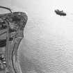
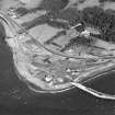
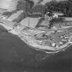
Accommodation camp for personnel serving the Pile Construction Yard and the Adminstrative Building (NX06NE 11.04). Most of the buildings have been reduced to their foundations and the field is now used for rough grazing.
Information from Defence of Britain Project recording form, 1997
The camp is visible on vertcial air photographs (106G/Scot/UK 987, 3135-3136, flown 9 November 1945), which show that there were at least 49 huts, mainly of the Nissen type, in an area N of Lochryan House.
Information from RCAHMS (DE), March 2006
NX06NE 11.10 NX c. 0628 6909

