
Scheduled Maintenance
Please be advised that this website will undergo scheduled maintenance on the following dates: •
Every Thursday from 17th October until 7th November from 11:00 to 15:00 •
Tuesday, 22nd October from 11:00 to 15:00
During these times, some services may be temporarily unavailable. We apologise for any inconvenience this may cause.
Cairnryan Harbour, Old House Point, Pile Construction Yard


Pile Construction Yard (20th Century), Railway Yard (20th Century)
Site Name Cairnryan Harbour, Old House Point, Pile Construction Yard
Classification Pile Construction Yard (20th Century), Railway Yard (20th Century)
Alternative Name(s) Cairnryan Military Railway
Canmore ID 178725
Site Number NX06NE 11.09
NGR NX 05873 69752
NGR Description Centred NX 05873 69752
Datum OSGB36 - NGR
Permalink http://canmore.org.uk/site/178725


- Council Dumfries And Galloway
- Parish Inch
- Former Region Dumfries And Galloway
- Former District Wigtown
- Former County Wigtownshire
NX06NE 11.09 centred 05873 69752
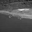
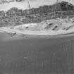
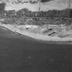
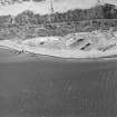
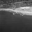
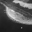
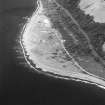
Situated at Old Hound Point, an area created to produce pre-fabricated concrete parts for the Military Port 1Km to the S. It was also the terminus of the Cairnryan Military railway. Surviving remains consist of abandoned railway sidings, slipways a wooden pier and concrete casting beds.
Built in early 1941 by the Royal Engineers.
The area is visible on vertical air photographs (106G/Scot/UK 987, 3134-3135, flown 9 November 1945), which show the railway sidings, buildings and slipways.
Information from RCAHMS (DE), March 2006
NX06NE 11.09 NX c. 0586 6975
Standing Building Recording (January 2010)
NX 058 697 (centred on) A field survey and standing building recording was carried out at Old House Point in
January 2010, prior to the proposed construction of a new ferry terminal c1km N of the current ferry port of Cairnryan. Prior to 1941 the site contained a cottage and the shed of the former Loch Ryan Oyster Co. After 1941 the site became a military fabrication yard which made cast concrete pier parts for the Cairnryan Military Harbour. In 1943 the site became a harbour yard in which Mulberry components were fabricated prior to being taken across the English Channel following the D-Day landings.
The remains of a collection of features associated with the 1941 pile construction yard and the later Mulberry fabrication site were recorded. The remains of the pier fabrication yard consisted of two rectilinear concrete casting beds >100m long and stockpiles of pier parts, which lay abandoned on either side. One of six beetle craft and various degraded building foundation blocks were surveyed and recorded. A Level 2 survey was undertaken of the cottage and a WW2 electric transformer block. A total of 41 features were recorded.
Archive: RCAHMS (intended). Reports: Dumfries and Galloway SMR and RCAHMS
Funder: Environmental Resource Management
Mike Cressey and Stuart Mitchell – CFA Archaeology Ltd

